
 Mikhaylovka
Dyrestuy
Mikhaylovka
Mayskiy
Novobessergenevka
Tersky District
Lesnoy
Tertezh
Kuz'minskiye Otverzhki
Mikhaylovka
Dyrestuy
Mikhaylovka
Mayskiy
Novobessergenevka
Tersky District
Lesnoy
Tertezh
Kuz'minskiye Otverzhki
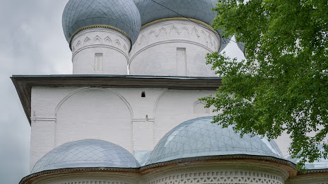
Sobor Uspeniya Presvyatoy Bogoroditsy on the map, Belozersk, Russian Federation
Photo
Where is located Sobor Uspeniya Presvyatoy Bogoroditsy
Sobor Uspeniya Presvyatoy Bogoroditsy — local attraction, which is located at Ulitsa Karla Marksa, 43, Belozersk, Vologda Oblast, 161200 and belongs to the category — cathedral. Average visitor rating for this place — 4.7 (according to 9 ratings, information from open sources and relevant for 2022).
Exact location — Sobor Uspeniya Presvyatoy Bogoroditsy, marked on the map with a red marker.
You can get directions to Sobor Uspeniya Presvyatoy Bogoroditsy on the map from your location.
What else is interesting in Belozersk? You can see all the sights if you go to the city page.
Coordinates
Sobor Uspeniya Presvyatoy Bogoroditsy, Russian Federation coordinates in decimal format: latitude — 60.0288315832112, longitude — 37.79582469846715. When converted to degrees, minutes, seconds Sobor Uspeniya Presvyatoy Bogoroditsy has the following coordinates: 60°1′43.79 north latitude and 37°47′44.97 east longitude.
Nearby cities
The largest cities that are located nearby:
- Cherepovets — 100 km
- Vologda — 151 km
- Rybinsk — 228 km
- Petrozavodsk — 264 km
- Yaroslavl — 294 km
- Kostroma — 313 km
- Tver — 368 km
- Kolpino — 401 km
- Saint Petersburg — 412 km
- Pushkino — 446 km
- Zelenograd — 448 km
- Khimki — 458 km
- Vladimir — 460 km
- Kovrov — 460 km
- Noginsk — 462 km
- Balashikha — 466 km
- Elektrostal — 472 km
- Orekhovo-Zuyevo — 474 km
- Lyubertsy — 481 km
Distance to the capital
Distance to the capital (Moscow) is about — 475 km.