
 Pointe-à-la-Croix
Sainte-Irène, Quebec
Marsoui
Hecla
Muskrat Dam
Wunnummin Lake
Sainte-Brigitte-de-Laval
Drayton
Mauricie
Pointe-à-la-Croix
Sainte-Irène, Quebec
Marsoui
Hecla
Muskrat Dam
Wunnummin Lake
Sainte-Brigitte-de-Laval
Drayton
Mauricie
Herald Provincial Park on the map, Salmon Arm, Canada
Photo
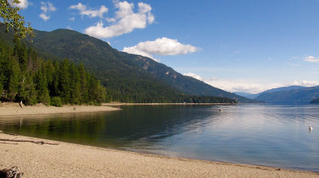
Where is located Herald Provincial Park
Herald Provincial Park — local attraction, which is located at 4861 Sunnybrae-Canoe Point Rd, Tappen, BC V0E 2X1, Canada and belongs to the category — provincial park. Average visitor rating for this place — 4.7 (according to 458 ratings, information from open sources and relevant for 2022).
Exact location — Herald Provincial Park, marked on the map with a red marker.
You can get directions to Herald Provincial Park on the map from your location.
What else is interesting in Salmon Arm? You can see all the sights if you go to the city page.
Coordinates
Herald Provincial Park, Canada coordinates in decimal format: latitude — 50.75064665359581, longitude — -119.22986066405424. When converted to degrees, minutes, seconds Herald Provincial Park has the following coordinates: 50°45′2.33 north latitude and -119°13′47.5 east longitude.
Nearby cities
The largest cities that are located nearby:
- Kelowna — 91 km
- Abbotsford — 286 km
- Coquitlam — 298 km
- Anmore — 300 km
- Surrey — 307 km
- Burnaby — 309 km
- Vancouver — 318 km
- Delta — 324 km
- Richmond — 326 km
- Spokane
 (United States) — 364 km
 - Calgary — 364 km
- Victoria — 391 km
- Bellevue (United States) — 405 km
- Seattle (United States) — 411 km
- Tacoma (United States) — 449 km
- Edmonton — 494 km
- Portland (United States) — 630 km
- Salem (United States) — 701 km
- Eugene (United States) — 795 km
Distance to the capital
Distance to the capital (Ottawa) is about — 3240 km.