
 Gilserberg
Berlin
Bordesholm
Bechtolsheim
Aub
Triptis
Heppenheim
Biblis
Angermünde
Gilserberg
Berlin
Bordesholm
Bechtolsheim
Aub
Triptis
Heppenheim
Biblis
Angermünde
Völklingen Ironworks on the map, Wadgassen, Germany
Photo
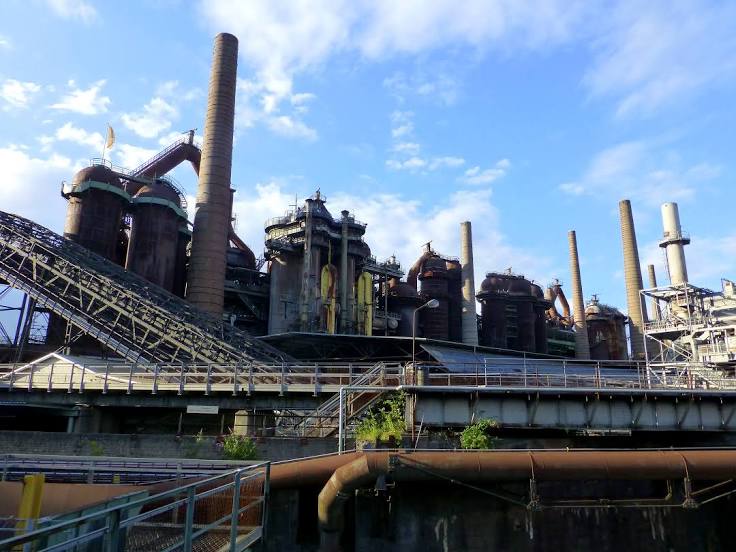
Where is located Völklingen Ironworks
Völklingen Ironworks — local attraction, which is located at Rathausstraße 75-79, 66333 Völklingen, Germany and belongs to the category — historical landmark. Average visitor rating for this place — 4.6 (according to 4358 ratings, information from open sources and relevant for 2022).
Exact location — Völklingen Ironworks, marked on the map with a red marker.
You can get directions to Völklingen Ironworks on the map from your location.
What else is interesting in Wadgassen? You can see all the sights if you go to the city page.
Coordinates
Völklingen Ironworks, Germany coordinates in decimal format: latitude — 49.248297754196074, longitude — 6.844292307922389. When converted to degrees, minutes, seconds Völklingen Ironworks has the following coordinates: 49°14′53.87 north latitude and 6°50′39.45 east longitude.
Nearby cities
The largest cities that are located nearby:
- Saarbrücken — 15 km
- Metz
 (France) — 47 km
 - Trier — 54 km
- Nancy (France) — 78 km
- Strasbourg (France) — 104 km
- Karlsruhe — 120 km
- Ludwigshafen — 121 km
- Mannheim — 123 km
- Mainz — 131 km
- Koblenz — 133 km
- Heidelberg — 136 km
- Wiesbaden — 136 km
- Pforzheim — 144 km
- Darmstadt — 148 km
- Freiburg — 160 km
- Frankfurt — 163 km
- Bonn — 164 km
- Offenbach — 168 km
- Mulhouse (France) — 173 km
Distance to the capital
Distance to the capital (Berlin) is about — 586 km.