
 Pfarrwerfen
Rosenau am Hengstpaß
Grinzens
Sankt Martin am Wöllmißberg
Sankt Martin am Silberberg
Söding
Felixdorf
Oberpullendorf District
Fließ
Pfarrwerfen
Rosenau am Hengstpaß
Grinzens
Sankt Martin am Wöllmißberg
Sankt Martin am Silberberg
Söding
Felixdorf
Oberpullendorf District
Fließ
Aigner Park on the map, Salzburg, Austria
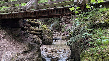
Photo
Where is located Aigner Park
Aigner Park — local attraction, which is located at 5026 Salzburg, Austria and belongs to the category — park. Average visitor rating for this place — 5.0 (according to 5 ratings, information from open sources and relevant for 2022).
Exact location — Aigner Park, marked on the map with a red marker.
You can get directions to Aigner Park on the map from your location.
What else is interesting in Salzburg? You can see all the sights if you go to the city page.
Coordinates
Aigner Park, Austria coordinates in decimal format: latitude — 47.78549431767805, longitude — 13.093142107870907. When converted to degrees, minutes, seconds Aigner Park has the following coordinates: 47°47′7.78 north latitude and 13°5′35.31 east longitude.
Nearby cities
The largest cities that are located nearby:
- Linz — 106 km
- Munich
 (Germany) — 115 km
 - Innsbruck — 138 km
- Regensburg (Germany) — 150 km
- Ingolstadt (Germany) — 159 km
- Augsburg (Germany) — 170 km
- Graz — 197 km
- Pilsen
 (Czech Republic) — 214 km
 - Ljubljana
 (Slovenia) — 223 km
 - Nuremberg (Germany) — 231 km
- Ulm (Germany) — 234 km
- Fürth (Germany) — 237 km
- Trento
 (Italy) — 243 km
 - Trieste (Italy) — 245 km
- Erlangen (Germany) — 245 km
- Venice (Italy) — 268 km
- Prague (Czech Republic) — 269 km
- Vicenza (Italy) — 277 km
- Reutlingen (Germany) — 292 km
Distance to the capital
Distance to the capital (Vienna) is about — 249 km.