
 Pfarrwerfen
Rosenau am Hengstpaß
Grinzens
Sankt Martin am Wöllmißberg
Sankt Martin am Silberberg
Söding
Felixdorf
Oberpullendorf District
Fließ
Pfarrwerfen
Rosenau am Hengstpaß
Grinzens
Sankt Martin am Wöllmißberg
Sankt Martin am Silberberg
Söding
Felixdorf
Oberpullendorf District
Fließ
Alberschwende - Brüggelekopf on the map, Dornbirn, Austria
Photo
Where is located Alberschwende - Brüggelekopf
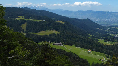
Alberschwende - Brüggelekopf — local attraction, which is located at Bühel 683, 6861 Alberschwende, Austria and belongs to the category — ski resort. Average visitor rating for this place — 4.4 (according to 56 ratings, information from open sources and relevant for 2022).
Exact location — Alberschwende - Brüggelekopf, marked on the map with a red marker.
You can get directions to Alberschwende - Brüggelekopf on the map from your location.
What else is interesting in Dornbirn? You can see all the sights if you go to the city page.
Coordinates
Alberschwende - Brüggelekopf, Austria coordinates in decimal format: latitude — 47.444695549333865, longitude — 9.853055483483136. When converted to degrees, minutes, seconds Alberschwende - Brüggelekopf has the following coordinates: 47°26′40.9 north latitude and 9°51′11 east longitude.
Nearby cities
The largest cities that are located nearby:
- Zurich
 (Switzerland) — 90 km
 - Ulm
 (Germany) — 111 km
 - Innsbruck — 126 km
- Reutlingen (Germany) — 127 km
- Augsburg (Germany) — 136 km
- Freiburg (Germany) — 155 km
- Stuttgart (Germany) — 156 km
- Munich (Germany) — 157 km
- Basel (Switzerland) — 161 km
- Pforzheim (Germany) — 181 km
- Bern (Switzerland) — 181 km
- Trento
 (Italy) — 182 km
 - Mulhouse
 (France) — 183 km
 - Bergamo (Italy) — 190 km
- Ingolstadt (Germany) — 193 km
- Strasbourg (France) — 194 km
- Heilbronn (Germany) — 195 km
- Karlsruhe (Germany) — 201 km
- Monza (Italy) — 205 km
Distance to the capital
Distance to the capital (Vienna) is about — 494 km.