
 Pfarrwerfen
Rosenau am Hengstpaß
Grinzens
Sankt Martin am Wöllmißberg
Sankt Martin am Silberberg
Söding
Felixdorf
Oberpullendorf District
Fließ
Pfarrwerfen
Rosenau am Hengstpaß
Grinzens
Sankt Martin am Wöllmißberg
Sankt Martin am Silberberg
Söding
Felixdorf
Oberpullendorf District
Fließ
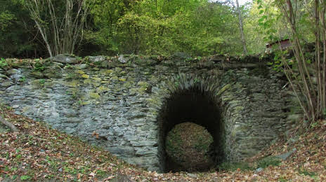
Römerbrücke on the map, Kapfenberg, Austria
Photo
Where is located Römerbrücke
Römerbrücke — local attraction, which is located at St. Dionysenstraße, 8600 Oberaich, Austria and belongs to the category — historical landmark. Average visitor rating for this place — 4.9 (according to 7 ratings, information from open sources and relevant for 2022).
Exact location — Römerbrücke, marked on the map with a red marker.
You can get directions to Römerbrücke on the map from your location.
What else is interesting in Kapfenberg? You can see all the sights if you go to the city page.
Coordinates
Römerbrücke, Austria coordinates in decimal format: latitude — 47.40733531482929, longitude — 15.223339898148568. When converted to degrees, minutes, seconds Römerbrücke has the following coordinates: 47°24′26.41 north latitude and 15°13′24.02 east longitude.
Nearby cities
The largest cities that are located nearby:
- Graz — 42 km
- Linz — 121 km
- Bratislava
 (Slovakia) — 156 km
 - Ljubljana
 (Slovenia) — 163 km
 - Salzburg — 171 km
- Győr
 (Hungary) — 178 km
 - Zagreb
 (Croatia) — 187 km
 - Brno
 (Czech Republic) — 217 km
 - Trieste
 (Italy) — 229 km
 - Székesfehérvár (Hungary) — 237 km
- Rijeka (Croatia) — 242 km
- Pécs (Hungary) — 272 km
- Olomouc (Czech Republic) — 277 km
- Budapest (Hungary) — 281 km
- Munich
 (Germany) — 284 km
 - Pilsen (Czech Republic) — 289 km
- Regensburg (Germany) — 289 km
- Innsbruck — 292 km
- Prague (Czech Republic) — 298 km
Distance to the capital
Distance to the capital (Vienna) is about — 124 km.