
 Pfarrwerfen
Rosenau am Hengstpaß
Grinzens
Sankt Martin am Wöllmißberg
Sankt Martin am Silberberg
Söding
Felixdorf
Oberpullendorf District
Fließ
Pfarrwerfen
Rosenau am Hengstpaß
Grinzens
Sankt Martin am Wöllmißberg
Sankt Martin am Silberberg
Söding
Felixdorf
Oberpullendorf District
Fließ
Michelberg on the map, Korneuburg, Austria
Photo
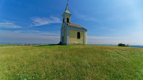
Where is located Michelberg
Michelberg — local attraction, which is located at no data and belongs to the category — -. Average visitor rating for this place — 4.5 (according to 11 ratings, information from open sources and relevant for 2022).
Exact location — Michelberg, marked on the map with a red marker.
You can get directions to Michelberg on the map from your location.
What else is interesting in Korneuburg? You can see all the sights if you go to the city page.
Coordinates
Michelberg, Austria coordinates in decimal format: latitude — 48.425722781496354, longitude — 16.286682498025627. When converted to degrees, minutes, seconds Michelberg has the following coordinates: 48°25′32.6 north latitude and 16°17′12.06 east longitude.
Nearby cities
The largest cities that are located nearby:
- Bratislava
 (Slovakia) — 61 km
 - Brno
 (Czech Republic) — 96 km
 - Győr
 (Hungary) — 122 km
 - Linz — 151 km
- Olomouc (Czech Republic) — 153 km
- Graz — 156 km
- Székesfehérvár (Hungary) — 203 km
- Ostrava (Czech Republic) — 214 km
- Budapest (Hungary) — 223 km
- Prague (Czech Republic) — 234 km
- Rybnik
 (Poland) — 250 km
 - Salzburg — 250 km
- Bielsko-Biala (Poland) — 254 km
- Pilsen (Czech Republic) — 262 km
- Walbrzych (Poland) — 270 km
- Gliwice (Poland) — 272 km
- Ruda Slaska (Poland) — 277 km
- Zabrze (Poland) — 279 km
- Opole (Poland) — 281 km
Distance to the capital
Distance to the capital (Vienna) is about — 25 km.