 Betteshanger
Lynton
Amesbury
Marlow
Burford
Chipping Norton
Marlborough
Cairnryan
Lydney
Betteshanger
Lynton
Amesbury
Marlow
Burford
Chipping Norton
Marlborough
Cairnryan
Lydney
Mugdock Castle on the map, Glasgow, United Kingdom
Photo
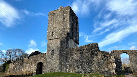
Where is located Mugdock Castle
Mugdock Castle — local attraction, which is located at Milngavie, Mugdock, Glasgow G62 8EL, United Kingdom and belongs to the category — tourist attraction. Average visitor rating for this place — 4.5 (according to 271 rating, information from open sources and relevant for 2022).
Exact location — Mugdock Castle, marked on the map with a red marker.
You can get directions to Mugdock Castle on the map from your location.
What else is interesting in Glasgow? You can see all the sights if you go to the city page.
Coordinates
Mugdock Castle, United Kingdom coordinates in decimal format: latitude — 55.9655935943506, longitude — -4.324582301536276. When converted to degrees, minutes, seconds Mugdock Castle has the following coordinates: 55°57′56.14 north latitude and -4°19′28.5 east longitude.
Nearby cities
The largest cities that are located nearby:
- Edinburgh — 67 km
- Belfast — 177 km
- Sunderland — 211 km
- Preston — 253 km
- Blackburn — 261 km
- Liverpool — 284 km
- Huddersfield — 294 km
- Manchester — 295 km
- Dublin
 (Ireland) — 308 km
 - Rotherham — 329 km
- Sheffield — 330 km
- Stoke-on-Trent — 345 km
- Telford — 372 km
- Dudley — 398 km
- Sutton Coldfield — 399 km
- West Bromwich — 400 km
- Birmingham — 406 km
- Leicester — 413 km
- Coventry — 424 km
Distance to the capital
Distance to the capital (London) is about — 567 km.