 Herbertstown
Dromagh
Roughgrove
Millstreet
County Dublin
Athy
Sallins
Ballybunnion
Fethard
Herbertstown
Dromagh
Roughgrove
Millstreet
County Dublin
Athy
Sallins
Ballybunnion
Fethard
Punchestown standing stone on the map, Naas, Ireland
Photo
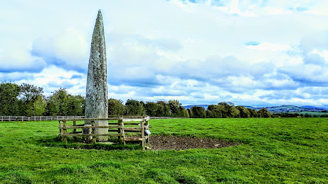
Where is located Punchestown standing stone
Punchestown standing stone — local attraction, which is located at L2023, Punchestown Great, Co. Kildare, Ireland and belongs to the category — historical landmark. Average visitor rating for this place — 3.7 (according to 6 ratings, information from open sources and relevant for 2022).
Exact location — Punchestown standing stone, marked on the map with a red marker.
You can get directions to Punchestown standing stone on the map from your location.
What else is interesting in Naas? You can see all the sights if you go to the city page.
Coordinates
Punchestown standing stone, Ireland coordinates in decimal format: latitude — 53.191794339678175, longitude — -6.628369501800831. When converted to degrees, minutes, seconds Punchestown standing stone has the following coordinates: 53°11′30.46 north latitude and -6°37′42.13 east longitude.
Nearby cities
The largest cities that are located nearby:
- Belfast
 (United Kingdom) — 159 km
 - Cork — 192 km
- Liverpool (United Kingdom) — 243 km
- Preston (United Kingdom) — 265 km
- Blackburn (United Kingdom) — 279 km
- Telford (United Kingdom) — 289 km
- Manchester (United Kingdom) — 292 km
- Stoke-on-Trent (United Kingdom) — 299 km
- Dudley (United Kingdom) — 318 km
- Worcester (Great Britain) — 321 km
- Huddersfield (United Kingdom) — 323 km
- West Bromwich (United Kingdom) — 323 km
- Glasgow (United Kingdom) — 328 km
- Birmingham (United Kingdom) — 331 km
- Sutton Coldfield (United Kingdom) — 333 km
- Bristol (Great Britain) — 342 km
- Sheffield (United Kingdom) — 343 km
- Cheltenham (United Kingdom) — 345 km
- Rotherham (United Kingdom) — 350 km
Distance to the capital
Distance to the capital (Dublin) is about — 30 km.