
 Pfarrwerfen
Rosenau am Hengstpaß
Grinzens
Sankt Martin am Wöllmißberg
Sankt Martin am Silberberg
Söding
Felixdorf
Oberpullendorf District
Fließ
Pfarrwerfen
Rosenau am Hengstpaß
Grinzens
Sankt Martin am Wöllmißberg
Sankt Martin am Silberberg
Söding
Felixdorf
Oberpullendorf District
Fließ
Lavanttal Alps on the map, Köflach, Austria
Photo
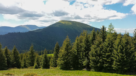
Where is located Lavanttal Alps
Lavanttal Alps — local attraction, which is located at Austria and belongs to the category — -. Average visitor rating for this place — 4.0 (according to 23 ratings, information from open sources and relevant for 2022).
Exact location — Lavanttal Alps, marked on the map with a red marker.
You can get directions to Lavanttal Alps on the map from your location.
What else is interesting in Köflach? You can see all the sights if you go to the city page.
Coordinates
Lavanttal Alps, Austria coordinates in decimal format: latitude — 47.069705816684056, longitude — 14.949999881386574. When converted to degrees, minutes, seconds Lavanttal Alps has the following coordinates: 47°4′10.94 north latitude and 14°56′60 east longitude.
Nearby cities
The largest cities that are located nearby:
- Graz — 27 km
- Ljubljana
 (Slovenia) — 120 km
 - Linz — 150 km
- Zagreb
 (Croatia) — 154 km
 - Salzburg — 172 km
- Trieste
 (Italy) — 186 km
 - Bratislava
 (Slovakia) — 192 km
 - Rijeka (Croatia) — 198 km
- Győr
 (Hungary) — 203 km
 - Székesfehérvár (Hungary) — 251 km
- Brno
 (Czech Republic) — 260 km
 - Pécs (Hungary) — 265 km
- Innsbruck — 277 km
- Venice (Italy) — 280 km
- Munich
 (Germany) — 284 km
 - Budapest (Hungary) — 300 km
- Banja Luka
 (Bosnia and Herzegovina) — 302 km
 - Regensburg (Germany) — 305 km
- Pilsen (Czech Republic) — 320 km
Distance to the capital
Distance to the capital (Vienna) is about — 166 km.