
 Ardena
Apiro
Cozzuolo
Amendolea
Grimaldi
Pignano
Case Nuove Russo
Palazzo
Lido di Rivoli
Ardena
Apiro
Cozzuolo
Amendolea
Grimaldi
Pignano
Case Nuove Russo
Palazzo
Lido di Rivoli
Monte Margiani on the map, Villacidro, Italy
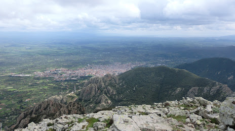
Photo
Where is located Monte Margiani
Monte Margiani — local attraction, which is located at 859 m and belongs to the category — -. Average visitor rating for this place — 4.3 (according to 6 ratings, information from open sources and relevant for 2022).
Exact location — Monte Margiani, marked on the map with a red marker.
You can get directions to Monte Margiani on the map from your location.
What else is interesting in Villacidro? You can see all the sights if you go to the city page.
Coordinates
Monte Margiani, Italy coordinates in decimal format: latitude — 39.46896384475055, longitude — 8.709060865635339. When converted to degrees, minutes, seconds Monte Margiani has the following coordinates: 39°28′8.27 north latitude and 8°42′32.62 east longitude.
Nearby cities
The largest cities that are located nearby:
- Cagliari — 42 km
- Sassari — 141 km
- Bizerte
 (Tunisia) — 262 km
 - Annaba
 (Algeria) — 296 km
 - Tunis (Tunisia) — 320 km
- Skikda (Algeria) — 330 km
- Guelma (Algeria) — 353 km
- Souk Ahras (Algeria) — 358 km
- Constantine (Algeria) — 393 km
- Latina — 410 km
- Palermo — 429 km
- Sousse (Tunisia) — 436 km
- Bejaia (Algeria) — 443 km
- Tebessa (Algeria) — 453 km
- Toulon
 (France) — 464 km
 - Setif (Algeria) — 467 km
- Terni — 467 km
- Livorno — 469 km
- Giugliano in Campania — 484 km
Distance to the capital
Distance to the capital (Rome) is about — 419 km.