 Betteshanger
Lynton
Amesbury
Marlow
Burford
Chipping Norton
Marlborough
Cairnryan
Lydney
Betteshanger
Lynton
Amesbury
Marlow
Burford
Chipping Norton
Marlborough
Cairnryan
Lydney
Clackmannan Tower on the map, Alloa, United Kingdom
Photo
Where is located Clackmannan Tower
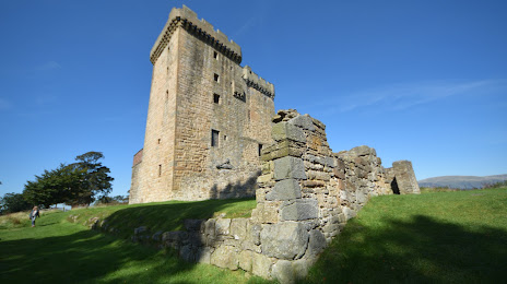
Clackmannan Tower — local attraction, which is located at High St, Clackmannan FK10 4HR, United Kingdom and belongs to the category — historical place. Average visitor rating for this place — 4.4 (according to 101 rating, information from open sources and relevant for 2022).
Exact location — Clackmannan Tower, marked on the map with a red marker.
You can get directions to Clackmannan Tower on the map from your location.
What else is interesting in Alloa? You can see all the sights if you go to the city page.
Coordinates
Clackmannan Tower, United Kingdom coordinates in decimal format: latitude — 56.107945574843995, longitude — -3.759598801530698. When converted to degrees, minutes, seconds Clackmannan Tower has the following coordinates: 56°6′28.6 north latitude and -3°45′34.56 east longitude.
Nearby cities
The largest cities that are located nearby:
- Glasgow — 40 km
- Edinburgh — 41 km
- Sunderland — 203 km
- Belfast — 217 km
- Preston — 269 km
- Blackburn — 275 km
- Huddersfield — 303 km
- Liverpool — 304 km
- Manchester — 308 km
- Rotherham — 337 km
- Sheffield — 339 km
- Dublin
 (Ireland) — 346 km
 - Stoke-on-Trent — 360 km
- Telford — 390 km
- Sutton Coldfield — 414 km
- Dudley — 415 km
- West Bromwich — 416 km
- Birmingham — 421 km
- Leicester — 424 km
Distance to the capital
Distance to the capital (London) is about — 564 km.