
 Puerto de la Duquesa
La Serna de Iguña
Pumalverde
Puentenansa
La Iglesia
Casar de Periedo
Fuengirola
Renedo de Piélagos
Villabanez
Puerto de la Duquesa
La Serna de Iguña
Pumalverde
Puentenansa
La Iglesia
Casar de Periedo
Fuengirola
Renedo de Piélagos
Villabanez
Playa de Areas on the map, Sanxenxo, Spain
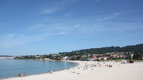
Photo
Where is located Playa de Areas
Playa de Areas — local attraction, which is located at no data and belongs to the category — -. Average visitor rating for this place — 4.7 (according to 263 ratings, information from open sources and relevant for 2022).
Exact location — Playa de Areas, marked on the map with a red marker.
You can get directions to Playa de Areas on the map from your location.
What else is interesting in Sanxenxo? You can see all the sights if you go to the city page.
Coordinates
Playa de Areas, Spain coordinates in decimal format: latitude — 42.39410228196385, longitude — -8.77955685201767. When converted to degrees, minutes, seconds Playa de Areas has the following coordinates: 42°23′38.77 north latitude and -8°46′46.4 east longitude.
Nearby cities
The largest cities that are located nearby:
- Vigo — 19 km
- Ourense — 78 km
- Braga
 (Portugal) — 100 km
 - A Coruña — 111 km
- Porto (Portugal) — 139 km
- Coimbra (Portugal) — 246 km
- Oviedo — 261 km
- León — 265 km
- Gijón — 282 km
- Salamanca — 307 km
- Valladolid — 348 km
- Amadora (Portugal) — 405 km
- Queluz (Portugal) — 405 km
- Lisbon (Portugal) — 408 km
- Burgos — 418 km
- Santander — 418 km
- Badajoz — 421 km
- Móstoles — 476 km
- Alcorcón — 478 km
Distance to the capital
Distance to the capital (Madrid) is about — 477 km.