 Betteshanger
Lynton
Amesbury
Marlow
Burford
Chipping Norton
Marlborough
Cairnryan
Lydney
Betteshanger
Lynton
Amesbury
Marlow
Burford
Chipping Norton
Marlborough
Cairnryan
Lydney
National Trust - The Firs: Elgar's Birthplace on the map, Worcester, United Kingdom
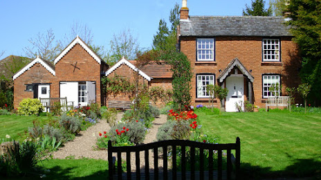
Photo
Where is located National Trust - The Firs: Elgar's Birthplace
National Trust - The Firs: Elgar's Birthplace — local attraction, which is located at Crown E Ln, Lower Broadheath, Upper Broadheath, Worcester WR2 6RH, United Kingdom and belongs to the category — $$. Average visitor rating for this place — 4.5 (according to 418 ratings, information from open sources and relevant for 2022).
Exact location — National Trust - The Firs: Elgar's Birthplace, marked on the map with a red marker.
You can get directions to National Trust - The Firs: Elgar's Birthplace on the map from your location.
What else is interesting in Worcester? You can see all the sights if you go to the city page.
Coordinates
National Trust - The Firs: Elgar's Birthplace, United Kingdom coordinates in decimal format: latitude — 52.19861559984674, longitude — -2.282599101837981. When converted to degrees, minutes, seconds National Trust - The Firs: Elgar's Birthplace has the following coordinates: 52°11′55.02 north latitude and -2°16′57.36 east longitude.
Nearby cities
The largest cities that are located nearby:
- Cheltenham — 34 km
- Dudley — 36 km
- West Bromwich — 39 km
- Birmingham — 39 km
- Sutton Coldfield — 49 km
- Coventry — 53 km
- Telford — 56 km
- Swindon — 77 km
- Oxford — 82 km
- Bristol — 86 km
- Leicester — 88 km
- Northampton — 89 km
- Stoke-on-Trent — 89 km
- Reading — 118 km
- Luton — 128 km
- Slough — 135 km
- Watford — 139 km
- Sheffield — 140 km
- Manchester — 142 km
Distance to the capital
Distance to the capital (London) is about — 167 km.