 Betteshanger
Lynton
Amesbury
Marlow
Burford
Chipping Norton
Marlborough
Cairnryan
Lydney
Betteshanger
Lynton
Amesbury
Marlow
Burford
Chipping Norton
Marlborough
Cairnryan
Lydney
National Trust - Hawford Dovecote on the map, Worcester, United Kingdom
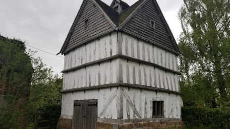
Photo
Where is located National Trust - Hawford Dovecote
National Trust - Hawford Dovecote — local attraction, which is located at Chatley Ln, Hawford, Worcester WR3 7SG, United Kingdom and belongs to the category — $$. Average visitor rating for this place — 3.7 (according to 11 ratings, information from open sources and relevant for 2022).
Exact location — National Trust - Hawford Dovecote, marked on the map with a red marker.
You can get directions to National Trust - Hawford Dovecote on the map from your location.
What else is interesting in Worcester? You can see all the sights if you go to the city page.
Coordinates
National Trust - Hawford Dovecote, United Kingdom coordinates in decimal format: latitude — 52.24382903331318, longitude — -2.2263808018362905. When converted to degrees, minutes, seconds National Trust - Hawford Dovecote has the following coordinates: 52°14′37.78 north latitude and -2°13′34.97 east longitude.
Nearby cities
The largest cities that are located nearby:
- Cheltenham — 34 km
- Dudley — 36 km
- West Bromwich — 39 km
- Birmingham — 39 km
- Sutton Coldfield — 49 km
- Coventry — 53 km
- Telford — 56 km
- Swindon — 77 km
- Oxford — 82 km
- Bristol — 86 km
- Leicester — 88 km
- Northampton — 89 km
- Stoke-on-Trent — 89 km
- Reading — 118 km
- Luton — 128 km
- Slough — 135 km
- Watford — 139 km
- Sheffield — 140 km
- Manchester — 142 km
Distance to the capital
Distance to the capital (London) is about — 166 km.