 Betteshanger
Lynton
Amesbury
Marlow
Burford
Chipping Norton
Marlborough
Cairnryan
Lydney
Betteshanger
Lynton
Amesbury
Marlow
Burford
Chipping Norton
Marlborough
Cairnryan
Lydney
Wellington Bowl on the map, Great Yarmouth, United Kingdom
Photo
Where is located Wellington Bowl
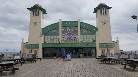
Wellington Bowl — local attraction, which is located at Wellington Pier, Marine Parade, Great Yarmouth NR30 3JF, United Kingdom and belongs to the category — leisure centre. Average visitor rating for this place — 4.2 (according to 352 ratings, information from open sources and relevant for 2022).
Exact location — Wellington Bowl, marked on the map with a red marker.
You can get directions to Wellington Bowl on the map from your location.
What else is interesting in Great Yarmouth? You can see all the sights if you go to the city page.
Coordinates
Wellington Bowl, United Kingdom coordinates in decimal format: latitude — 52.599428118334664, longitude — 1.7377582983353421. When converted to degrees, minutes, seconds Wellington Bowl has the following coordinates: 52°35′57.94 north latitude and 1°44′15.93 east longitude.
Nearby cities
The largest cities that are located nearby:
- Norwich — 29 km
- Ipswich — 72 km
- Cambridge — 117 km
- Chelmsford — 129 km
- Southend-on-Sea — 136 km
- Basildon — 142 km
- Gillingham — 157 km
- Luton — 167 km
- Watford — 179 km
- Northampton — 182 km
- The Hague
 (Netherlands) — 184 km
 - Sutton — 191 km
- Leicester — 192 km
- Leiden (Netherlands) — 194 km
- Zoetermeer (Netherlands) — 197 km
- Haarlem (Netherlands) — 198 km
- Slough — 200 km
- Rotterdam (Netherlands) — 202 km
- Hoofddorp (Netherlands) — 203 km
Distance to the capital
Distance to the capital (London) is about — 176 km.