 Betteshanger
Lynton
Amesbury
Marlow
Burford
Chipping Norton
Marlborough
Cairnryan
Lydney
Betteshanger
Lynton
Amesbury
Marlow
Burford
Chipping Norton
Marlborough
Cairnryan
Lydney
St Helen C Of E Church on the map, Hatfield, United Kingdom
Photo
Where is located St Helen C Of E Church
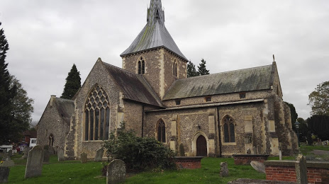
St Helen C Of E Church — local attraction, which is located at High St, Wheathampstead, St Albans AL4 8AA, United Kingdom and belongs to the category — church. Average visitor rating for this place — 4.6 (according to 20 ratings, information from open sources and relevant for 2022).
Exact location — St Helen C Of E Church, marked on the map with a red marker.
You can get directions to St Helen C Of E Church on the map from your location.
What else is interesting in Hatfield? You can see all the sights if you go to the city page.
Coordinates
St Helen C Of E Church, United Kingdom coordinates in decimal format: latitude — 51.812273819964446, longitude — -0.2934219402294692. When converted to degrees, minutes, seconds St Helen C Of E Church has the following coordinates: 51°48′44.19 north latitude and -0°17′36.32 east longitude.
Nearby cities
The largest cities that are located nearby:
- Watford — 16 km
- Luton — 19 km
- Slough — 38 km
- Sutton — 44 km
- Chelmsford — 47 km
- Basildon — 53 km
- Cambridge — 54 km
- Reading — 62 km
- Gillingham — 68 km
- Southend-on-Sea — 68 km
- Northampton — 70 km
- Oxford — 71 km
- Crawley — 72 km
- Ipswich — 99 km
- Swindon — 109 km
- Coventry — 113 km
- Leicester — 114 km
- Eastbourne — 116 km
- Portsmouth — 121 km
Distance to the capital
Distance to the capital (London) is about — 36 km.