
 Gilserberg
Berlin
Bordesholm
Bechtolsheim
Aub
Triptis
Heppenheim
Biblis
Angermünde
Gilserberg
Berlin
Bordesholm
Bechtolsheim
Aub
Triptis
Heppenheim
Biblis
Angermünde
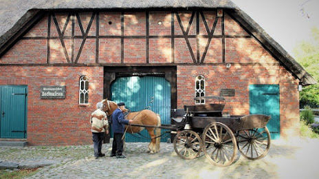
Stormarnsches Dorfmuseum on the map, Ahrensburg, Germany
Photo
Where is located Stormarnsches Dorfmuseum
Stormarnsches Dorfmuseum — local attraction, which is located at Sprenger Weg 1, 22955 Hoisdorf, Germany and belongs to the category — museum. Average visitor rating for this place — 4.7 (according to 22 ratings, information from open sources and relevant for 2022).
Exact location — Stormarnsches Dorfmuseum, marked on the map with a red marker.
You can get directions to Stormarnsches Dorfmuseum on the map from your location.
What else is interesting in Ahrensburg? You can see all the sights if you go to the city page.
Coordinates
Stormarnsches Dorfmuseum, Germany coordinates in decimal format: latitude — 53.65535781328939, longitude — 10.333306159839447. When converted to degrees, minutes, seconds Stormarnsches Dorfmuseum has the following coordinates: 53°39′19.29 north latitude and 10°19′59.9 east longitude.
Nearby cities
The largest cities that are located nearby:
- Kiel — 72 km
- Bremerhaven — 110 km
- Bremen — 116 km
- Rostock — 129 km
- Wolfsburg — 143 km
- Hanover — 148 km
- Brunswick — 157 km
- Salzgitter — 169 km
- Hildesheim — 169 km
- Odense
 (Denmark) — 191 km
 - Magdeburg — 196 km
- Osnabrück — 214 km
- Bielefeld — 216 km
- Göttingen — 237 km
- Potsdam — 238 km
- Paderborn — 239 km
- Emmen
 (Netherlands) — 244 km
 - Groningen (Netherlands) — 248 km
- Berlin — 249 km
Distance to the capital
Distance to the capital (Berlin) is about — 241 km.