 Betteshanger
Lynton
Amesbury
Marlow
Burford
Chipping Norton
Marlborough
Cairnryan
Lydney
Betteshanger
Lynton
Amesbury
Marlow
Burford
Chipping Norton
Marlborough
Cairnryan
Lydney
Croxteth Hall & Country Park on the map, Liverpool, United Kingdom
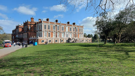
Photo
Where is located Croxteth Hall & Country Park
Croxteth Hall & Country Park — local attraction, which is located at Muirhead Ave E, Liverpool L11 1EH, United Kingdom and belongs to the category — park. Average visitor rating for this place — 4.6 (according to 2007 ratings, information from open sources and relevant for 2022).
Exact location — Croxteth Hall & Country Park, marked on the map with a red marker.
You can get directions to Croxteth Hall & Country Park on the map from your location.
What else is interesting in Liverpool? You can see all the sights if you go to the city page.
Coordinates
Croxteth Hall & Country Park, United Kingdom coordinates in decimal format: latitude — 53.443146808209, longitude — -2.8973893798710897. When converted to degrees, minutes, seconds Croxteth Hall & Country Park has the following coordinates: 53°26′35.33 north latitude and -2°53′50.6 east longitude.
Nearby cities
The largest cities that are located nearby:
- Preston — 44 km
- Manchester — 50 km
- Blackburn — 50 km
- Stoke-on-Trent — 70 km
- Huddersfield — 83 km
- Telford — 89 km
- Sheffield — 100 km
- Rotherham — 107 km
- Dudley — 116 km
- West Bromwich — 119 km
- Sutton Coldfield — 121 km
- Birmingham — 126 km
- Worcester — 144 km
- Coventry — 149 km
- Leicester — 151 km
- Cheltenham — 178 km
- Northampton — 192 km
- Sunderland — 195 km
- Dublin
 (Ireland) — 216 km
Distance to the capital
Distance to the capital (London) is about — 286 km.