
 Pfarrwerfen
Rosenau am Hengstpaß
Grinzens
Sankt Martin am Wöllmißberg
Sankt Martin am Silberberg
Söding
Felixdorf
Oberpullendorf District
Fließ
Pfarrwerfen
Rosenau am Hengstpaß
Grinzens
Sankt Martin am Wöllmißberg
Sankt Martin am Silberberg
Söding
Felixdorf
Oberpullendorf District
Fließ
Burg Greifenstein on the map, Stockerau, Austria
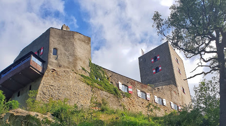
Photo
Where is located Burg Greifenstein
Burg Greifenstein — local attraction, which is located at Kostersitzgasse 5, 3422 St. Andrä-Wördern, Austria and belongs to the category — castle. Average visitor rating for this place — 4.0 (according to 56 ratings, information from open sources and relevant for 2022).
Exact location — Burg Greifenstein, marked on the map with a red marker.
You can get directions to Burg Greifenstein on the map from your location.
What else is interesting in Stockerau? You can see all the sights if you go to the city page.
Coordinates
Burg Greifenstein, Austria coordinates in decimal format: latitude — 48.34746286925991, longitude — 16.248826859645682. When converted to degrees, minutes, seconds Burg Greifenstein has the following coordinates: 48°20′50.87 north latitude and 16°14′55.78 east longitude.
Nearby cities
The largest cities that are located nearby:
- Bratislava
 (Slovakia) — 71 km
 - Brno
 (Czech Republic) — 94 km
 - Győr
 (Hungary) — 132 km
 - Linz — 142 km
- Olomouc (Czech Republic) — 153 km
- Graz — 157 km
- Székesfehérvár (Hungary) — 212 km
- Ostrava (Czech Republic) — 216 km
- Prague (Czech Republic) — 225 km
- Budapest (Hungary) — 233 km
- Salzburg — 243 km
- Rybnik
 (Poland) — 252 km
 - Pilsen (Czech Republic) — 252 km
- Bielsko-Biala (Poland) — 258 km
- Walbrzych (Poland) — 265 km
- Gliwice (Poland) — 273 km
- Ruda Slaska (Poland) — 278 km
- Opole (Poland) — 280 km
- Zabrze (Poland) — 281 km
Distance to the capital
Distance to the capital (Vienna) is about — 18 km.