
 Gilserberg
Berlin
Bordesholm
Bechtolsheim
Aub
Triptis
Heppenheim
Biblis
Angermünde
Gilserberg
Berlin
Bordesholm
Bechtolsheim
Aub
Triptis
Heppenheim
Biblis
Angermünde
Stadtmuseum & Bäder-Museum on the map, Rostock, Germany
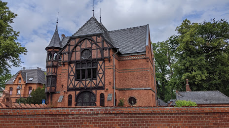
Photo
Where is located Stadtmuseum & Bäder-Museum
Stadtmuseum & Bäder-Museum — local attraction, which is located at Beethovenstraße 8, 18209 Bad Doberan, Germany and belongs to the category — museum. Average visitor rating for this place — 4.3 (according to 81 rating, information from open sources and relevant for 2022).
Exact location — Stadtmuseum & Bäder-Museum, marked on the map with a red marker.
You can get directions to Stadtmuseum & Bäder-Museum on the map from your location.
What else is interesting in Rostock? You can see all the sights if you go to the city page.
Coordinates
Stadtmuseum & Bäder-Museum, Germany coordinates in decimal format: latitude — 54.08719711964019, longitude — 12.132933159855863. When converted to degrees, minutes, seconds Stadtmuseum & Bäder-Museum has the following coordinates: 54°5′13.91 north latitude and 12°7′58.56 east longitude.
Nearby cities
The largest cities that are located nearby:
- Kiel — 130 km
- Malmö
 (Sweden) — 177 km
 - Copenhagen
 (Denmark) — 178 km
 - Szczecin
 (Poland) — 178 km
 - Odense (Denmark) — 180 km
- Berlin — 197 km
- Potsdam — 199 km
- Wolfsburg — 205 km
- Magdeburg — 220 km
- Brunswick — 228 km
- Bremerhaven — 239 km
- Salzgitter — 246 km
- Bremen — 246 km
- Hanover — 248 km
- Aarhus (Denmark) — 257 km
- Gorzów Wielkopolski (Poland) — 258 km
- Hildesheim — 259 km
- Koszalin (Poland) — 264 km
- Cottbus — 300 km
Distance to the capital
Distance to the capital (Berlin) is about — 194 km.