
 Pfarrwerfen
Rosenau am Hengstpaß
Grinzens
Sankt Martin am Wöllmißberg
Sankt Martin am Silberberg
Söding
Felixdorf
Oberpullendorf District
Fließ
Pfarrwerfen
Rosenau am Hengstpaß
Grinzens
Sankt Martin am Wöllmißberg
Sankt Martin am Silberberg
Söding
Felixdorf
Oberpullendorf District
Fließ
St. Peter an der Sperr on the map, Wiener Neustadt, Austria
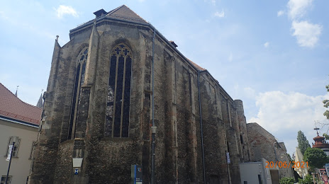
Photo
Where is located St. Peter an der Sperr
St. Peter an der Sperr — local attraction, which is located at Johannes-von-Nepomuk-Platz 1, 2700 Wiener Neustadt, Austria and belongs to the category — historical landmark. Average visitor rating for this place — 4.5 (according to 192 ratings, information from open sources and relevant for 2022).
Exact location — St. Peter an der Sperr, marked on the map with a red marker.
You can get directions to St. Peter an der Sperr on the map from your location.
What else is interesting in Wiener Neustadt? You can see all the sights if you go to the city page.
Coordinates
St. Peter an der Sperr, Austria coordinates in decimal format: latitude — 47.815843687762026, longitude — 16.24415335962718. When converted to degrees, minutes, seconds St. Peter an der Sperr has the following coordinates: 47°48′57.04 north latitude and 16°14′38.95 east longitude.
Nearby cities
The largest cities that are located nearby:
- Bratislava
 (Slovakia) — 75 km
 - Graz — 101 km
- Győr
 (Hungary) — 106 km
 - Linz — 154 km
- Brno
 (Czech Republic) — 156 km
 - Székesfehérvár (Hungary) — 178 km
- Olomouc (Czech Republic) — 211 km
- Budapest (Hungary) — 212 km
- Zagreb
 (Croatia) — 221 km
 - Ljubljana
 (Slovenia) — 234 km
 - Salzburg — 236 km
- Pécs (Hungary) — 245 km
- Ostrava (Czech Republic) — 266 km
- Kecskemét (Hungary) — 280 km
- Prague (Czech Republic) — 282 km
- Pilsen (Czech Republic) — 296 km
- Bielsko-Biala
 (Poland) — 301 km
 - Rybnik (Poland) — 303 km
- Trieste
 (Italy) — 305 km
Distance to the capital
Distance to the capital (Vienna) is about — 45 km.