
 Pfarrwerfen
Rosenau am Hengstpaß
Grinzens
Sankt Martin am Wöllmißberg
Sankt Martin am Silberberg
Söding
Felixdorf
Oberpullendorf District
Fließ
Pfarrwerfen
Rosenau am Hengstpaß
Grinzens
Sankt Martin am Wöllmißberg
Sankt Martin am Silberberg
Söding
Felixdorf
Oberpullendorf District
Fließ
Burgruine Alt-Ems on the map, Hohenems, Austria
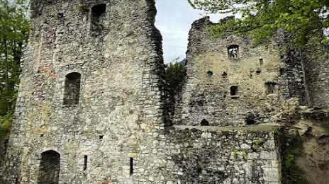
Photo
Where is located Burgruine Alt-Ems
Burgruine Alt-Ems — local attraction, which is located at 6845 Hohenems, Austria and belongs to the category — historical place. Average visitor rating for this place — 4.8 (according to 238 ratings, information from open sources and relevant for 2022).
Exact location — Burgruine Alt-Ems, marked on the map with a red marker.
You can get directions to Burgruine Alt-Ems on the map from your location.
What else is interesting in Hohenems? You can see all the sights if you go to the city page.
Coordinates
Burgruine Alt-Ems, Austria coordinates in decimal format: latitude — 47.364287139123554, longitude — 9.69695895961146. When converted to degrees, minutes, seconds Burgruine Alt-Ems has the following coordinates: 47°21′51.43 north latitude and 9°41′49.05 east longitude.
Nearby cities
The largest cities that are located nearby:
- Zurich
 (Switzerland) — 86 km
 - Ulm
 (Germany) — 117 km
 - Innsbruck — 129 km
- Reutlingen (Germany) — 132 km
- Augsburg (Germany) — 143 km
- Freiburg (Germany) — 154 km
- Basel (Switzerland) — 158 km
- Stuttgart (Germany) — 161 km
- Munich (Germany) — 164 km
- Bern (Switzerland) — 175 km
- Mulhouse
 (France) — 180 km
 - Trento
 (Italy) — 180 km
 - Bergamo (Italy) — 184 km
- Pforzheim (Germany) — 184 km
- Strasbourg (France) — 195 km
- Monza (Italy) — 199 km
- Heilbronn (Germany) — 200 km
- Ingolstadt (Germany) — 201 km
- Karlsruhe (Germany) — 204 km
Distance to the capital
Distance to the capital (Vienna) is about — 508 km.