
 Pfarrwerfen
Rosenau am Hengstpaß
Grinzens
Sankt Martin am Wöllmißberg
Sankt Martin am Silberberg
Söding
Felixdorf
Oberpullendorf District
Fließ
Pfarrwerfen
Rosenau am Hengstpaß
Grinzens
Sankt Martin am Wöllmißberg
Sankt Martin am Silberberg
Söding
Felixdorf
Oberpullendorf District
Fließ
Zinkenlifte Hallein / Bad Dürrnberg on the map, Hallein, Austria
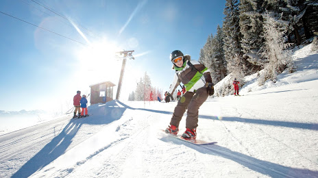
Photo
Where is located Zinkenlifte Hallein / Bad Dürrnberg
Zinkenlifte Hallein / Bad Dürrnberg — local attraction, which is located at Weißenwäschweg 19, 5422 Bad Dürrnberg, Austria and belongs to the category — ski resort. Average visitor rating for this place — 4.5 (according to 203 ratings, information from open sources and relevant for 2022).
Exact location — Zinkenlifte Hallein / Bad Dürrnberg, marked on the map with a red marker.
You can get directions to Zinkenlifte Hallein / Bad Dürrnberg on the map from your location.
What else is interesting in Hallein? You can see all the sights if you go to the city page.
Coordinates
Zinkenlifte Hallein / Bad Dürrnberg, Austria coordinates in decimal format: latitude — 47.65945246105192, longitude — 13.09221562518177. When converted to degrees, minutes, seconds Zinkenlifte Hallein / Bad Dürrnberg has the following coordinates: 47°39′34.03 north latitude and 13°5′31.98 east longitude.
Nearby cities
The largest cities that are located nearby:
- Salzburg — 14 km
- Linz — 111 km
- Munich
 (Germany) — 123 km
 - Innsbruck — 135 km
- Regensburg (Germany) — 164 km
- Ingolstadt (Germany) — 171 km
- Augsburg (Germany) — 179 km
- Graz — 189 km
- Ljubljana
 (Slovenia) — 210 km
 - Pilsen
 (Czech Republic) — 228 km
 - Trieste
 (Italy) — 231 km
 - Trento (Italy) — 234 km
- Ulm (Germany) — 242 km
- Nuremberg (Germany) — 244 km
- Fürth (Germany) — 250 km
- Venice (Italy) — 255 km
- Erlangen (Germany) — 259 km
- Vicenza (Italy) — 266 km
- Rijeka
 (Croatia) — 281 km
Distance to the capital
Distance to the capital (Vienna) is about — 252 km.