
 Pfarrwerfen
Rosenau am Hengstpaß
Grinzens
Sankt Martin am Wöllmißberg
Sankt Martin am Silberberg
Söding
Felixdorf
Oberpullendorf District
Fließ
Pfarrwerfen
Rosenau am Hengstpaß
Grinzens
Sankt Martin am Wöllmißberg
Sankt Martin am Silberberg
Söding
Felixdorf
Oberpullendorf District
Fließ
Husarentempel on the map, Mödling, Austria
Photo
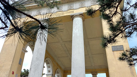
Where is located Husarentempel
Husarentempel — local attraction, which is located at 2340 Mödling, Austria and belongs to the category — tourist attraction. Average visitor rating for this place — 4.7 (according to 553 ratings, information from open sources and relevant for 2022).
Exact location — Husarentempel, marked on the map with a red marker.
You can get directions to Husarentempel on the map from your location.
What else is interesting in Mödling? You can see all the sights if you go to the city page.
Coordinates
Husarentempel, Austria coordinates in decimal format: latitude — 48.077014922018996, longitude — 16.251660625196322. When converted to degrees, minutes, seconds Husarentempel has the following coordinates: 48°4′37.25 north latitude and 16°15′5.98 east longitude.
Nearby cities
The largest cities that are located nearby:
- Bratislava
 (Slovakia) — 61 km
 - Győr
 (Hungary) — 110 km
 - Brno
 (Czech Republic) — 125 km
 - Graz — 129 km
- Linz — 149 km
- Olomouc (Czech Republic) — 181 km
- Székesfehérvár (Hungary) — 189 km
- Budapest (Hungary) — 216 km
- Ostrava (Czech Republic) — 238 km
- Salzburg — 242 km
- Zagreb
 (Croatia) — 252 km
 - Prague (Czech Republic) — 256 km
- Ljubljana
 (Slovenia) — 262 km
 - Pécs (Hungary) — 268 km
- Rybnik
 (Poland) — 275 km
 - Bielsko-Biala (Poland) — 276 km
- Pilsen (Czech Republic) — 277 km
- Kecskemét (Hungary) — 289 km
- Gliwice (Poland) — 297 km
Distance to the capital
Distance to the capital (Vienna) is about — 17 km.