
 Puerto de la Duquesa
La Serna de Iguña
Pumalverde
Puentenansa
La Iglesia
Casar de Periedo
Fuengirola
Renedo de Piélagos
Villabanez
Puerto de la Duquesa
La Serna de Iguña
Pumalverde
Puentenansa
La Iglesia
Casar de Periedo
Fuengirola
Renedo de Piélagos
Villabanez
Basílica Santa María de Portugalete on the map, Sestao, Spain
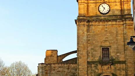
Photo
Where is located Basílica Santa María de Portugalete
Basílica Santa María de Portugalete — local attraction, which is located at Canton de la Iglesia Kalea, 6, 48920 Portugalete, Bizkaia, Spain and belongs to the category — cathedral. Average visitor rating for this place — 4.5 (according to 744 ratings, information from open sources and relevant for 2022).
Exact location — Basílica Santa María de Portugalete, marked on the map with a red marker.
You can get directions to Basílica Santa María de Portugalete on the map from your location.
What else is interesting in Sestao? You can see all the sights if you go to the city page.
Coordinates
Basílica Santa María de Portugalete, Spain coordinates in decimal format: latitude — 43.31979295388958, longitude — -3.0167500749636043. When converted to degrees, minutes, seconds Basílica Santa María de Portugalete has the following coordinates: 43°19′11.25 north latitude and -3°1′0.3 east longitude.
Nearby cities
The largest cities that are located nearby:
- Bilbao — 8 km
- Vitoria-Gasteiz — 56 km
- Santander — 67 km
- San Sebastián — 83 km
- Logroño — 104 km
- Burgos — 121 km
- Pamplona — 123 km
- Gijón — 214 km
- León — 223 km
- Oviedo — 229 km
- Valladolid — 232 km
- Zaragoza — 254 km
- Bordeaux
 (France) — 255 km
 - Alcobendas — 311 km
- Alcala de Henares — 314 km
- Torrejón de Ardoz — 318 km
- Alcorcón — 335 km
- Leganés — 335 km
- Getafe — 337 km
Distance to the capital
Distance to the capital (Madrid) is about — 328 km.