 Herbertstown
Dromagh
Roughgrove
Millstreet
County Dublin
Athy
Sallins
Ballybunnion
Fethard
Herbertstown
Dromagh
Roughgrove
Millstreet
County Dublin
Athy
Sallins
Ballybunnion
Fethard
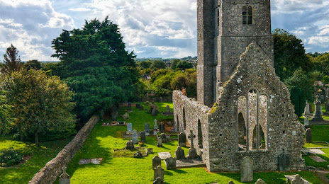
St. Mary's Abbey, Duleek on the map, Drogheda, Ireland
Photo
Where is located St. Mary's Abbey, Duleek
St. Mary's Abbey, Duleek — local attraction, which is located at Moss Rose, Main St, Abbeyland, Duleek, Co. Meath, Ireland and belongs to the category — monastery. Average visitor rating for this place — 5.0 (according to 1 rating, information from open sources and relevant for 2022).
Exact location — St. Mary's Abbey, Duleek, marked on the map with a red marker.
You can get directions to St. Mary's Abbey, Duleek on the map from your location.
What else is interesting in Drogheda? You can see all the sights if you go to the city page.
Coordinates
St. Mary's Abbey, Duleek, Ireland coordinates in decimal format: latitude — 53.65503306727102, longitude — -6.418895974600473. When converted to degrees, minutes, seconds St. Mary's Abbey, Duleek has the following coordinates: 53°39′18.12 north latitude and -6°25′8.03 east longitude.
Nearby cities
The largest cities that are located nearby:
- Belfast
 (United Kingdom) — 101 km
 - Liverpool (United Kingdom) — 224 km
- Preston (United Kingdom) — 239 km
- Cork — 248 km
- Blackburn (United Kingdom) — 253 km
- Glasgow (United Kingdom) — 271 km
- Manchester (United Kingdom) — 272 km
- Telford (United Kingdom) — 286 km
- Stoke-on-Trent (United Kingdom) — 289 km
- Huddersfield (United Kingdom) — 300 km
- Edinburgh (United Kingdom) — 315 km
- Dudley (United Kingdom) — 317 km
- West Bromwich (United Kingdom) — 322 km
- Sheffield (United Kingdom) — 324 km
- Worcester (Great Britain) — 327 km
- Sutton Coldfield (United Kingdom) — 330 km
- Birmingham (United Kingdom) — 330 km
- Rotherham (United Kingdom) — 330 km
- Sunderland (United Kingdom) — 342 km
Distance to the capital
Distance to the capital (Dublin) is about — 36 km.