
 Puerto de la Duquesa
La Serna de Iguña
Pumalverde
Puentenansa
La Iglesia
Casar de Periedo
Fuengirola
Renedo de Piélagos
Villabanez
Puerto de la Duquesa
La Serna de Iguña
Pumalverde
Puentenansa
La Iglesia
Casar de Periedo
Fuengirola
Renedo de Piélagos
Villabanez
Yacimiento Arqueológico de Castulo on the map, Linares, Spain
Photo
Where is located Yacimiento Arqueológico de Castulo
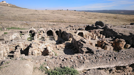
Yacimiento Arqueológico de Castulo — local attraction, which is located at 23700 Linares, Jaén, Spain and belongs to the category — tourist attraction. Average visitor rating for this place — 4.4 (according to 265 ratings, information from open sources and relevant for 2022).
Exact location — Yacimiento Arqueológico de Castulo, marked on the map with a red marker.
You can get directions to Yacimiento Arqueológico de Castulo on the map from your location.
What else is interesting in Linares? You can see all the sights if you go to the city page.
Coordinates
Yacimiento Arqueológico de Castulo, Spain coordinates in decimal format: latitude — 38.038523054744736, longitude — -3.6238731751252984. When converted to degrees, minutes, seconds Yacimiento Arqueológico de Castulo has the following coordinates: 38°2′18.68 north latitude and -3°37′25.94 east longitude.
Nearby cities
The largest cities that are located nearby:
- Jaén — 37 km
- Granada — 102 km
- Córdoba — 102 km
- Málaga — 167 km
- Almería — 174 km
- Albacete — 182 km
- Marbella — 207 km
- Murcia — 219 km
- Dos Hermanas — 220 km
- Cartagena — 237 km
- Fuenlabrada — 243 km
- Getafe — 245 km
- Móstoles — 247 km
- Leganés — 247 km
- Alcorcón — 249 km
- Torrejón de Ardoz — 261 km
- Alcala de Henares — 265 km
- Alcobendas — 270 km
- Jerez — 270 km
Distance to the capital
Distance to the capital (Madrid) is about — 265 km.