
 Gilserberg
Berlin
Bordesholm
Bechtolsheim
Aub
Triptis
Heppenheim
Biblis
Angermünde
Gilserberg
Berlin
Bordesholm
Bechtolsheim
Aub
Triptis
Heppenheim
Biblis
Angermünde
Maritim Museum Peenemünde U-461 on the map, Wolgast, Germany
Photo
Where is located Maritim Museum Peenemünde U-461
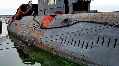
Maritim Museum Peenemünde U-461 — local attraction, which is located at Haupthafen, 17449 Peenemünde, Germany and belongs to the category — maritime museum. Average visitor rating for this place — 4.2 (according to 3240 ratings, information from open sources and relevant for 2022).
Exact location — Maritim Museum Peenemünde U-461, marked on the map with a red marker.
You can get directions to Maritim Museum Peenemünde U-461 on the map from your location.
What else is interesting in Wolgast? You can see all the sights if you go to the city page.
Coordinates
Maritim Museum Peenemünde U-461, Germany coordinates in decimal format: latitude — 54.13482869402247, longitude — 13.76661812541772. When converted to degrees, minutes, seconds Maritim Museum Peenemünde U-461 has the following coordinates: 54°8′5.38 north latitude and 13°45′59.83 east longitude.
Nearby cities
The largest cities that are located nearby:
- Szczecin
 (Poland) — 86 km
 - Rostock — 108 km
- Koszalin (Poland) — 156 km
- Berlin — 173 km
- Gorzów Wielkopolski (Poland) — 176 km
- Malmö
 (Sweden) — 178 km
 - Potsdam — 189 km
- Copenhagen
 (Denmark) — 195 km
 - Kiel — 237 km
- Cottbus — 256 km
- Magdeburg — 258 km
- Odense (Denmark) — 259 km
- Zielona Gora (Poland) — 262 km
- Wolfsburg — 270 km
- Poznań (Poland) — 280 km
- Brunswick — 295 km
- Bydgoszcz (Poland) — 300 km
- Gdynia (Poland) — 310 km
- Salzgitter — 314 km
Distance to the capital
Distance to the capital (Berlin) is about — 181 km.