 Betteshanger
Lynton
Amesbury
Marlow
Burford
Chipping Norton
Marlborough
Cairnryan
Lydney
Betteshanger
Lynton
Amesbury
Marlow
Burford
Chipping Norton
Marlborough
Cairnryan
Lydney
Cedar Farm on the map, Chorley, United Kingdom
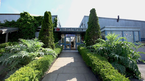
Photo
Where is located Cedar Farm
Cedar Farm — local attraction, which is located at cedar farm, Back Ln, Mawdesley, Ormskirk L40 3SY, United Kingdom and belongs to the category — art studio. Average visitor rating for this place — 4.5 (according to 831 rating, information from open sources and relevant for 2022).
Exact location — Cedar Farm, marked on the map with a red marker.
You can get directions to Cedar Farm on the map from your location.
What else is interesting in Chorley? You can see all the sights if you go to the city page.
Coordinates
Cedar Farm, United Kingdom coordinates in decimal format: latitude — 53.62014604359049, longitude — -2.7655459746017983. When converted to degrees, minutes, seconds Cedar Farm has the following coordinates: 53°37′12.53 north latitude and -2°45′55.97 east longitude.
Nearby cities
The largest cities that are located nearby:
- Preston — 13 km
- Blackburn — 14 km
- Manchester — 32 km
- Liverpool — 36 km
- Huddersfield — 56 km
- Stoke-on-Trent — 78 km
- Sheffield — 82 km
- Rotherham — 87 km
- Telford — 109 km
- Sutton Coldfield — 132 km
- Dudley — 132 km
- West Bromwich — 133 km
- Birmingham — 138 km
- Leicester — 151 km
- Coventry — 157 km
- Sunderland — 160 km
- Worcester — 164 km
- Northampton — 195 km
- Cheltenham — 198 km
Distance to the capital
Distance to the capital (London) is about — 295 km.