 Betteshanger
Lynton
Amesbury
Marlow
Burford
Chipping Norton
Marlborough
Cairnryan
Lydney
Betteshanger
Lynton
Amesbury
Marlow
Burford
Chipping Norton
Marlborough
Cairnryan
Lydney
Irish Linen Centre & Lisburn Museum on the map, Belfast, United Kingdom
Photo
Where is located Irish Linen Centre & Lisburn Museum
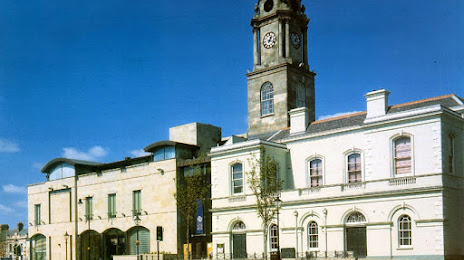
Irish Linen Centre & Lisburn Museum — local attraction, which is located at Market Square, Lisburn BT28 1AG, United Kingdom and belongs to the category — museum. Average visitor rating for this place — 4.4 (according to 243 ratings, information from open sources and relevant for 2022).
Exact location — Irish Linen Centre & Lisburn Museum, marked on the map with a red marker.
You can get directions to Irish Linen Centre & Lisburn Museum on the map from your location.
What else is interesting in Belfast? You can see all the sights if you go to the city page.
Coordinates
Irish Linen Centre & Lisburn Museum, United Kingdom coordinates in decimal format: latitude — 54.51109775166279, longitude — -6.043440474567885. When converted to degrees, minutes, seconds Irish Linen Centre & Lisburn Museum has the following coordinates: 54°30′39.95 north latitude and -6°2′36.39 east longitude.
Nearby cities
The largest cities that are located nearby:
- Dublin
 (Ireland) — 140 km
 - Glasgow — 175 km
- Edinburgh — 226 km
- Preston — 230 km
- Liverpool — 234 km
- Blackburn — 244 km
- Manchester — 272 km
- Sunderland — 291 km
- Huddersfield — 291 km
- Stoke-on-Trent — 306 km
- Telford — 316 km
- Sheffield — 323 km
- Rotherham — 327 km
- Cork (Ireland) — 346 km
- Dudley — 347 km
- West Bromwich — 351 km
- Sutton Coldfield — 355 km
- Birmingham — 358 km
- Worcester — 366 km
Distance to the capital
Distance to the capital (London) is about — 518 km.