

Kans Quila, Mathura on the map, Mathura, India
Photo
Where is located Kans Quila, Mathura
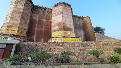
Kans Quila, Mathura — local attraction, which is located at Ratankund, Chowk Bazar, Mathura, Uttar Pradesh 281001, India and belongs to the category — castle. Average visitor rating for this place — 3.7 (according to 934 ratings, information from open sources and relevant for 2022).
Exact location — Kans Quila, Mathura, marked on the map with a red marker.
You can get directions to Kans Quila, Mathura on the map from your location.
What else is interesting in Mathura? You can see all the sights if you go to the city page.
Coordinates
Kans Quila, Mathura, India coordinates in decimal format: latitude — 27.507911261290484, longitude — 77.68209152460713. When converted to degrees, minutes, seconds Kans Quila, Mathura has the following coordinates: 27°30′28.48 north latitude and 77°40′55.53 east longitude.
Nearby cities
The largest cities that are located nearby:
- Bharatpur — 35 km
- Agra — 48 km
- Firozabad — 80 km
- Alwar — 102 km
- Faridabad — 107 km
- Morena — 114 km
- Noida — 119 km
- Gurgaon — 124 km
- Rewari — 128 km
- Ghaziabad — 132 km
- North West Delhi — 143 km
- Delhi — 145 km
- Gwalior — 150 km
- Meerut — 165 km
- Moradabad — 183 km
- Rohtak — 187 km
- Bareilly — 196 km
- Jaipur — 197 km
- Shahjahanpur — 223 km
Distance to the capital
Distance to the capital (New Delhi) is about — 131 km.