

Nanda devi Mandir on the map, Almora, India
Photo
Where is located Nanda devi Mandir
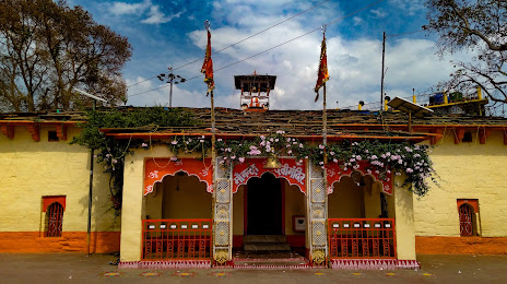
Nanda devi Mandir — local attraction, which is located at Unnamed Road, Dharanaula, Almora, Uttarakhand 263601, India and belongs to the category — hindu temple. Average visitor rating for this place — 4.5 (according to 65 ratings, information from open sources and relevant for 2022).
Exact location — Nanda devi Mandir, marked on the map with a red marker.
You can get directions to Nanda devi Mandir on the map from your location.
What else is interesting in Almora? You can see all the sights if you go to the city page.
Coordinates
Nanda devi Mandir, India coordinates in decimal format: latitude — 29.599842302981703, longitude — 79.66100762465412. When converted to degrees, minutes, seconds Nanda devi Mandir has the following coordinates: 29°35′59.43 north latitude and 79°39′39.63 east longitude.
Nearby cities
The largest cities that are located nearby:
- Haldwani — 43 km
- Kashipur — 78 km
- Moradabad — 119 km
- Bareilly — 137 km
- Haridwar — 147 km
- Roorkee — 171 km
- Shahjahanpur — 190 km
- Meerut — 199 km
- Saharanpur — 205 km
- Ghaziabad — 236 km
- Noida — 248 km
- Karnal — 255 km
- Faridabad — 261 km
- North West Delhi — 263 km
- Delhi — 265 km
- Gurgaon — 284 km
- Ambala — 287 km
- Shimla — 288 km
- Firozabad — 296 km
Distance to the capital
Distance to the capital (New Delhi) is about — 262 km.