

Kappil Beach on the map, Kasaragod, India
Photo
Where is located Kappil Beach
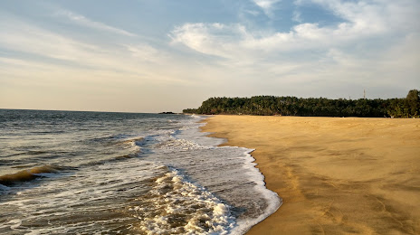
Kappil Beach — local attraction, which is located at Palakunnu Complex, Edappally - Panvel Hwy, Kappil, Bekal, Kerala 671319, India and belongs to the category — public beach. Average visitor rating for this place — 4.2 (according to 102 ratings, information from open sources and relevant for 2022).
Exact location — Kappil Beach, marked on the map with a red marker.
You can get directions to Kappil Beach on the map from your location.
What else is interesting in Kasaragod? You can see all the sights if you go to the city page.
Coordinates
Kappil Beach, India coordinates in decimal format: latitude — 12.424004792064242, longitude — 75.01167002436573. When converted to degrees, minutes, seconds Kappil Beach has the following coordinates: 12°25′26.42 north latitude and 75°0′42.01 east longitude.
Nearby cities
The largest cities that are located nearby:
- Mangaluru — 47 km
- Udupi — 95 km
- Hassan — 132 km
- Kozhikode — 163 km
- Thrissur — 257 km
- Palakkad — 263 km
- Coimbatore — 270 km
- Tiruppur — 299 km
- Hosur — 307 km
- Hubli — 316 km
- Kochi — 317 km
- Erode — 321 km
- Vasco da Gama — 340 km
- Mormugao — 344 km
- Kolar — 346 km
- Salem — 355 km
- Ballari — 357 km
- Alappuzha — 364 km
- Belgaum — 373 km
Distance to the capital
Distance to the capital (New Delhi) is about — 1815 km.