 Betteshanger
Lynton
Amesbury
Marlow
Burford
Chipping Norton
Marlborough
Cairnryan
Lydney
Betteshanger
Lynton
Amesbury
Marlow
Burford
Chipping Norton
Marlborough
Cairnryan
Lydney
Kinneil Local Nature Reserve on the map, Falkirk, United Kingdom
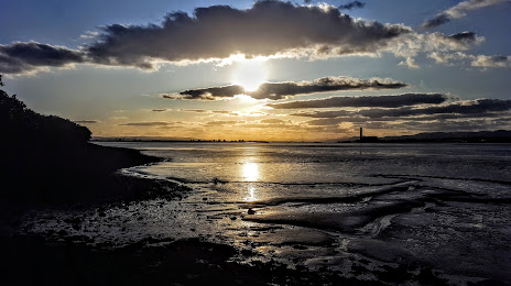
Photo
Where is located Kinneil Local Nature Reserve
Kinneil Local Nature Reserve — local attraction, which is located at Unnamed Road, Bo'ness EH51 0PS, United Kingdom and belongs to the category — nature preserve. Average visitor rating for this place — 4.6 (according to 54 ratings, information from open sources and relevant for 2022).
Exact location — Kinneil Local Nature Reserve, marked on the map with a red marker.
You can get directions to Kinneil Local Nature Reserve on the map from your location.
What else is interesting in Falkirk? You can see all the sights if you go to the city page.
Coordinates
Kinneil Local Nature Reserve, United Kingdom coordinates in decimal format: latitude — 56.01619909425162, longitude — -3.628754574509788. When converted to degrees, minutes, seconds Kinneil Local Nature Reserve has the following coordinates: 56°0′58.32 north latitude and -3°37′43.52 east longitude.
Nearby cities
The largest cities that are located nearby:
- Glasgow — 33 km
- Edinburgh — 37 km
- Sunderland — 195 km
- Belfast — 207 km
- Preston — 257 km
- Blackburn — 263 km
- Liverpool — 291 km
- Huddersfield — 292 km
- Manchester — 297 km
- Rotherham — 326 km
- Sheffield — 327 km
- Dublin
 (Ireland) — 336 km
 - Stoke-on-Trent — 348 km
- Telford — 378 km
- Sutton Coldfield — 402 km
- Dudley — 402 km
- West Bromwich — 404 km
- Birmingham — 409 km
- Leicester — 412 km
Distance to the capital
Distance to the capital (London) is about — 552 km.