 Betteshanger
Lynton
Amesbury
Marlow
Burford
Chipping Norton
Marlborough
Cairnryan
Lydney
Betteshanger
Lynton
Amesbury
Marlow
Burford
Chipping Norton
Marlborough
Cairnryan
Lydney
Egypt Centre on the map, Swansea, United Kingdom
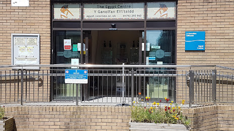
Photo
Where is located Egypt Centre
Egypt Centre — local attraction, which is located at Swansea University Singleton Park Campus, Swansea SA2 8PP, United Kingdom and belongs to the category — museum. Average visitor rating for this place — 4.6 (according to 74 ratings, information from open sources and relevant for 2022).
Exact location — Egypt Centre, marked on the map with a red marker.
You can get directions to Egypt Centre on the map from your location.
What else is interesting in Swansea? You can see all the sights if you go to the city page.
Coordinates
Egypt Centre, United Kingdom coordinates in decimal format: latitude — 51.61015749750364, longitude — -3.9787340746768285. When converted to degrees, minutes, seconds Egypt Centre has the following coordinates: 51°36′36.57 north latitude and -3°58′43.44 east longitude.
Nearby cities
The largest cities that are located nearby:
- Bristol — 95 km
- Exeter — 104 km
- Cheltenham — 131 km
- Worcester — 133 km
- Swindon — 149 km
- Telford — 154 km
- Dudley — 159 km
- West Bromwich — 164 km
- Birmingham — 168 km
- Bournemouth — 176 km
- Sutton Coldfield — 177 km
- Oxford — 184 km
- Coventry — 185 km
- Stoke-on-Trent — 193 km
- Southampton — 194 km
- Reading — 205 km
- Liverpool — 207 km
- Northampton — 217 km
- Portsmouth — 218 km
Distance to the capital
Distance to the capital (London) is about — 267 km.