
 Vítkovce
Harhaj
Blatná Polianka
Orlov
Bzenov
Chrastné
Dolná Poruba
Kvačany
Kožuchovce
Vítkovce
Harhaj
Blatná Polianka
Orlov
Bzenov
Chrastné
Dolná Poruba
Kvačany
Kožuchovce
Ormet Teplý vrch on the map, Rimavská Sobota, Slovakia
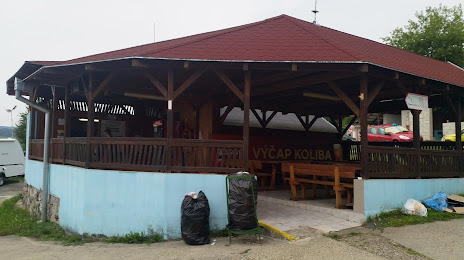
Photo
Where is located Ormet Teplý vrch
Ormet Teplý vrch — local attraction, which is located at Pokoradzká 5, 979 01 Rimavská Sobota, Slovakia and belongs to the category — park. Average visitor rating for this place — 3.5 (according to 4 ratings, information from open sources and relevant for 2022).
Exact location — Ormet Teplý vrch, marked on the map with a red marker.
You can get directions to Ormet Teplý vrch on the map from your location.
What else is interesting in Rimavská Sobota? You can see all the sights if you go to the city page.
Coordinates
Ormet Teplý vrch, Slovakia coordinates in decimal format: latitude — 48.39211422008681, longitude — 20.02484162520731. When converted to degrees, minutes, seconds Ormet Teplý vrch has the following coordinates: 48°23′31.61 north latitude and 20°1′29.43 east longitude.
Nearby cities
The largest cities that are located nearby:
- Miskolc
 (Hungary) — 63 km
 - Košice — 98 km
- Budapest (Hungary) — 122 km
- Nyíregyháza (Hungary) — 135 km
- Debrecen (Hungary) — 153 km
- Kecskemét (Hungary) — 166 km
- Uzhhorod
 (Ukraine) — 168 km
 - Bielsko-Biala
 (Poland) — 173 km
 - Székesfehérvár (Hungary) — 179 km
- Kraków (Poland) — 186 km
- Győr (Hungary) — 192 km
- Tarnow (Poland) — 193 km
- Ostrava
 (Czech Republic) — 202 km
 - Oradea
 (Romania) — 204 km
 - Rybnik (Poland) — 217 km
- Katowice (Poland) — 220 km
- Sosnowiec (Poland) — 220 km
- Dabrowa Gornicza (Poland) — 222 km
- Ruda Slaska (Poland) — 223 km
Distance to the capital
Distance to the capital (Bratislava) is about — 218 km.