
 Pithoro
Kandhra
Sultan Kot
Rahimabad
Mithiani
New Jatoi
Ratanabad
Bhaledino Kaka
Arija
Pithoro
Kandhra
Sultan Kot
Rahimabad
Mithiani
New Jatoi
Ratanabad
Bhaledino Kaka
Arija
Samundar Katha on the map, Abbottābad, Pakistan
Photo
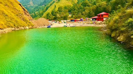
Where is located Samundar Katha
Samundar Katha — local attraction, which is located at no data and belongs to the category — -. Average visitor rating for this place — 4.2 (according to 319 ratings, information from open sources and relevant for 2022).
Exact location — Samundar Katha, marked on the map with a red marker.
You can get directions to Samundar Katha on the map from your location.
What else is interesting in Abbottābad? You can see all the sights if you go to the city page.
Coordinates
Samundar Katha, Pakistan coordinates in decimal format: latitude — 34.12423498817762, longitude — 73.33185469507895. When converted to degrees, minutes, seconds Samundar Katha has the following coordinates: 34°7′27.25 north latitude and 73°19′54.68 east longitude.
Nearby cities
The largest cities that are located nearby:
- Wah — 63 km
- Rawalpindi — 65 km
- Kotli
 — 96 km
 - Mingora — 103 km
- Mardan — 107 km
- Chakwal — 141 km
- Jhelum — 144 km
- Srinagar
 — 145 km
 - Peshawar — 151 km
- Mandi Bahauddin — 177 km
- Kohat — 177 km
- Wazirabad — 209 km
- Jammu — 220 km
- Khushāb — 222 km
- Siālkot — 222 km
- Daska — 229 km
- Hafizabad — 236 km
- Sargodha — 236 km
- Gujranwala — 240 km
Distance to the capital
Distance to the capital (Islamabad) is about — 49 km.