 Betteshanger
Lynton
Amesbury
Marlow
Burford
Chipping Norton
Marlborough
Cairnryan
Lydney
Betteshanger
Lynton
Amesbury
Marlow
Burford
Chipping Norton
Marlborough
Cairnryan
Lydney
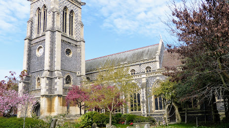
St Mary-le-Tower on the map, Ipswich, United Kingdom
Photo
Where is located St Mary-le-Tower
St Mary-le-Tower — local attraction, which is located at Tower St, Ipswich IP1 3BE, United Kingdom and belongs to the category — anglican church. Average visitor rating for this place — 4.7 (according to 49 ratings, information from open sources and relevant for 2022).
Exact location — St Mary-le-Tower, marked on the map with a red marker.
You can get directions to St Mary-le-Tower on the map from your location.
What else is interesting in Ipswich? You can see all the sights if you go to the city page.
Coordinates
St Mary-le-Tower, United Kingdom coordinates in decimal format: latitude — 52.05836939452344, longitude — 1.1553846253397286. When converted to degrees, minutes, seconds St Mary-le-Tower has the following coordinates: 52°3′30.13 north latitude and 1°9′19.38 east longitude.
Nearby cities
The largest cities that are located nearby:
- Chelmsford — 59 km
- Southend-on-Sea — 64 km
- Norwich — 64 km
- Basildon — 70 km
- Cambridge — 71 km
- Gillingham — 85 km
- Luton — 109 km
- Watford — 114 km
- Sutton — 120 km
- Slough — 134 km
- Crawley — 140 km
- Northampton — 140 km
- Eastbourne — 155 km
- Reading — 161 km
- Leicester — 166 km
- Oxford — 168 km
- Coventry — 184 km
- Lille
 (France) — 207 km
 - Portsmouth — 208 km
Distance to the capital
Distance to the capital (London) is about — 107 km.