 Betteshanger
Lynton
Amesbury
Marlow
Burford
Chipping Norton
Marlborough
Cairnryan
Lydney
Betteshanger
Lynton
Amesbury
Marlow
Burford
Chipping Norton
Marlborough
Cairnryan
Lydney
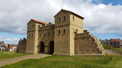
Arbeia, South Shields Roman Fort on the map, Whitley Bay, United Kingdom
Photo
Where is located Arbeia, South Shields Roman Fort
Arbeia, South Shields Roman Fort — local attraction, which is located at Baring St, South Shields NE33 2BB, United Kingdom and belongs to the category — museum. Average visitor rating for this place — 4.5 (according to 569 ratings, information from open sources and relevant for 2022).
Exact location — Arbeia, South Shields Roman Fort, marked on the map with a red marker.
You can get directions to Arbeia, South Shields Roman Fort on the map from your location.
What else is interesting in Whitley Bay? You can see all the sights if you go to the city page.
Coordinates
Arbeia, South Shields Roman Fort, United Kingdom coordinates in decimal format: latitude — 55.004073991048024, longitude — -1.4320571745489798. When converted to degrees, minutes, seconds Arbeia, South Shields Roman Fort has the following coordinates: 55°0′14.67 north latitude and -1°25′55.41 east longitude.
Nearby cities
The largest cities that are located nearby:
- Sunderland — 16 km
- Edinburgh — 147 km
- Huddersfield — 156 km
- Blackburn — 159 km
- Preston — 164 km
- Rotherham — 179 km
- Manchester — 181 km
- Sheffield — 184 km
- Glasgow — 196 km
- Liverpool — 208 km
- Stoke-on-Trent — 231 km
- Leicester — 267 km
- Telford — 270 km
- Sutton Coldfield — 275 km
- West Bromwich — 282 km
- Dudley — 283 km
- Birmingham — 285 km
- Belfast — 291 km
- Coventry — 292 km
Distance to the capital
Distance to the capital (London) is about — 398 km.