
 Puerto de la Duquesa
La Serna de Iguña
Pumalverde
Puentenansa
La Iglesia
Casar de Periedo
Fuengirola
Renedo de Piélagos
Villabanez
Puerto de la Duquesa
La Serna de Iguña
Pumalverde
Puentenansa
La Iglesia
Casar de Periedo
Fuengirola
Renedo de Piélagos
Villabanez
Salar de los Canos on the map, Vera, Spain
Photo
Where is located Salar de los Canos
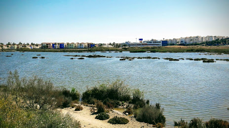
Salar de los Canos — local attraction, which is located at 04621 Playas de Vera, Almería, Spain and belongs to the category — nature preserve. Average visitor rating for this place — 3.9 (according to 16 ratings, information from open sources and relevant for 2022).
Exact location — Salar de los Canos, marked on the map with a red marker.
You can get directions to Salar de los Canos on the map from your location.
What else is interesting in Vera? You can see all the sights if you go to the city page.
Coordinates
Salar de los Canos, Spain coordinates in decimal format: latitude — 37.22088713424332, longitude — -1.8121496751487693. When converted to degrees, minutes, seconds Salar de los Canos has the following coordinates: 37°13′15.19 north latitude and -1°48′43.74 east longitude.
Nearby cities
The largest cities that are located nearby:
- Almería — 70 km
- Cartagena — 87 km
- Murcia — 104 km
- Granada — 153 km
- Jaén — 178 km
- Albacete — 193 km
- Oran
 (Algeria) — 204 km
 - Málaga — 234 km
- Nador
 (Morocco) — 249 km
 - Sidi Bel Abbes (Algeria) — 252 km
- Córdoba — 264 km
- Tlemcen (Algeria) — 266 km
- Relizane (Algeria) — 274 km
- Valencia — 277 km
- Marbella — 280 km
- Oujda (Morocco) — 283 km
- Chlef (Algeria) — 310 km
- Saida (Algeria) — 323 km
- Algeciras — 343 km
Distance to the capital
Distance to the capital (Madrid) is about — 391 km.