
 Pfarrwerfen
Rosenau am Hengstpaß
Grinzens
Sankt Martin am Wöllmißberg
Sankt Martin am Silberberg
Söding
Felixdorf
Oberpullendorf District
Fließ
Pfarrwerfen
Rosenau am Hengstpaß
Grinzens
Sankt Martin am Wöllmißberg
Sankt Martin am Silberberg
Söding
Felixdorf
Oberpullendorf District
Fließ
Bergbahnen Westendorf GmbH on the map, Wörgl, Austria
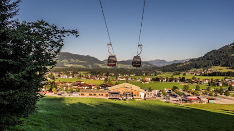
Photo
Where is located Bergbahnen Westendorf GmbH
Bergbahnen Westendorf GmbH — local attraction, which is located at Bergliftstraße 18, 6363 Westendorf, Austria and belongs to the category — mountain cable car. Average visitor rating for this place — 4.6 (according to 903 ratings, information from open sources and relevant for 2022).
Exact location — Bergbahnen Westendorf GmbH, marked on the map with a red marker.
You can get directions to Bergbahnen Westendorf GmbH on the map from your location.
What else is interesting in Wörgl? You can see all the sights if you go to the city page.
Coordinates
Bergbahnen Westendorf GmbH, Austria coordinates in decimal format: latitude — 47.4275396168587, longitude — 12.21376862517371. When converted to degrees, minutes, seconds Bergbahnen Westendorf GmbH has the following coordinates: 47°25′39.14 north latitude and 12°12′49.57 east longitude.
Nearby cities
The largest cities that are located nearby:
- Innsbruck — 55 km
- Munich
 (Germany) — 80 km
 - Salzburg — 82 km
- Augsburg (Germany) — 130 km
- Ingolstadt (Germany) — 149 km
- Regensburg (Germany) — 169 km
- Trento
 (Italy) — 172 km
 - Ulm (Germany) — 183 km
- Linz — 187 km
- Vicenza (Italy) — 218 km
- Venice (Italy) — 227 km
- Nuremberg (Germany) — 229 km
- Fürth (Germany) — 233 km
- Reutlingen (Germany) — 238 km
- Verona (Italy) — 241 km
- Trieste (Italy) — 242 km
- Erlangen (Germany) — 245 km
- Ljubljana
 (Slovenia) — 245 km
 - Stuttgart (Germany) — 254 km
Distance to the capital
Distance to the capital (Vienna) is about — 323 km.