 Betteshanger
Lynton
Amesbury
Marlow
Burford
Chipping Norton
Marlborough
Cairnryan
Lydney
Betteshanger
Lynton
Amesbury
Marlow
Burford
Chipping Norton
Marlborough
Cairnryan
Lydney
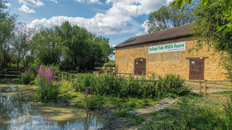
Bradlaugh Fields & Barn on the map, Northampton, United Kingdom
Photo
Where is located Bradlaugh Fields & Barn
Bradlaugh Fields & Barn — local attraction, which is located at Fulford Dr, Northampton NN2 7NX, United Kingdom and belongs to the category — park. Average visitor rating for this place — 4.4 (according to 327 ratings, information from open sources and relevant for 2022).
Exact location — Bradlaugh Fields & Barn, marked on the map with a red marker.
You can get directions to Bradlaugh Fields & Barn on the map from your location.
What else is interesting in Northampton? You can see all the sights if you go to the city page.
Coordinates
Bradlaugh Fields & Barn, United Kingdom coordinates in decimal format: latitude — 52.26478243192234, longitude — -0.8807313746526081. When converted to degrees, minutes, seconds Bradlaugh Fields & Barn has the following coordinates: 52°15′53.22 north latitude and -0°52′50.63 east longitude.
Nearby cities
The largest cities that are located nearby:
- Coventry — 46 km
- Leicester — 47 km
- Luton — 52 km
- Oxford — 59 km
- Cambridge — 70 km
- Birmingham — 72 km
- Sutton Coldfield — 72 km
- Watford — 74 km
- West Bromwich — 80 km
- Slough — 83 km
- Dudley — 85 km
- Reading — 87 km
- Cheltenham — 89 km
- Worcester — 90 km
- Swindon — 97 km
- Sutton — 109 km
- Chelmsford — 109 km
- Telford — 114 km
- Stoke-on-Trent — 120 km
Distance to the capital
Distance to the capital (London) is about — 99 km.