Where is located Ramgarh Taal on the map, Gorakhpur, India. Geographic coordinates in decimal format, as well as degrees, minutes and seconds. Photo, address and average rating of visitors who have been here.
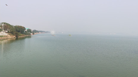
Ramgarh Taal — local attraction, which is located at 7.23 km² and belongs to the category — -. Average visitor rating for this place — 4.4 (according to 952 ratings, information from open sources and relevant for 2022).
Exact location — Ramgarh Taal, marked on the map with a red marker.
What else is interesting in Gorakhpur? You can see all the sights if you go to the city page.
Coordinates
Ramgarh Taal, India coordinates in decimal format: latitude — 26.727347004606116, longitude — 83.40137136206884. When converted to degrees, minutes, seconds Ramgarh Taal has the following coordinates: 26°43′38.45 north latitude and 83°24′4.94 east longitude.
Nearby cities
The largest cities that are located nearby:
Basti — 61 km
Faizabad — 121 km
Ghazipur — 132 km
Chhapra — 175 km
Pokhara (Nepal) — 176 km
Allahabad — 211 km
Patan (Nepal) — 215 km
Kathmandu (Nepal) — 218 km
Lucknow — 240 km
Fatehpur — 271 km
Kanpur — 303 km
Banda — 335 km
Munger — 344 km
Jamalpur — 350 km
Shahjahanpur — 360 km
Bareilly — 423 km
Ranchi — 426 km
Haldwani — 461 km
Distance to the capital
Distance to the capital (New Delhi) is about — 645 km.


 (Nepal) — 176 km