 Betteshanger
Lynton
Amesbury
Marlow
Burford
Chipping Norton
Marlborough
Cairnryan
Lydney
Betteshanger
Lynton
Amesbury
Marlow
Burford
Chipping Norton
Marlborough
Cairnryan
Lydney
St Peter's Church, Wallsend on the map, Hebburn, United Kingdom
Photo
Where is located St Peter's Church, Wallsend
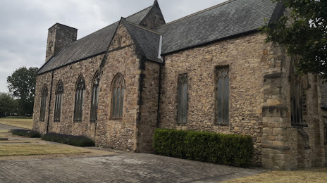
St Peter's Church, Wallsend — local attraction, which is located at 98 Church Bank, Wallsend NE28 7LH, United Kingdom and belongs to the category — church. Average visitor rating for this place — 4.7 (according to 6 ratings, information from open sources and relevant for 2022).
Exact location — St Peter's Church, Wallsend, marked on the map with a red marker.
You can get directions to St Peter's Church, Wallsend on the map from your location.
What else is interesting in Hebburn? You can see all the sights if you go to the city page.
Coordinates
St Peter's Church, Wallsend, United Kingdom coordinates in decimal format: latitude — 54.9946220845215, longitude — -1.5174551745493574. When converted to degrees, minutes, seconds St Peter's Church, Wallsend has the following coordinates: 54°59′40.64 north latitude and -1°31′2.84 east longitude.
Nearby cities
The largest cities that are located nearby:
- Sunderland — 11 km
- Huddersfield — 148 km
- Blackburn — 149 km
- Edinburgh — 150 km
- Preston — 154 km
- Rotherham — 171 km
- Manchester — 172 km
- Sheffield — 176 km
- Glasgow — 196 km
- Liverpool — 198 km
- Stoke-on-Trent — 222 km
- Leicester — 259 km
- Telford — 261 km
- Sutton Coldfield — 266 km
- West Bromwich — 273 km
- Dudley — 275 km
- Birmingham — 276 km
- Coventry — 284 km
- Belfast — 285 km
Distance to the capital
Distance to the capital (London) is about — 399 km.