 Betteshanger
Lynton
Amesbury
Marlow
Burford
Chipping Norton
Marlborough
Cairnryan
Lydney
Betteshanger
Lynton
Amesbury
Marlow
Burford
Chipping Norton
Marlborough
Cairnryan
Lydney
Pegwell Nature Reserve on the map, Broadstairs, United Kingdom
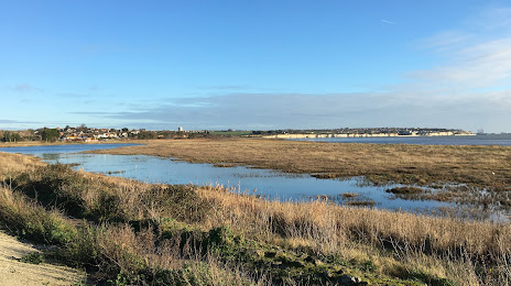
Photo
Where is located Pegwell Nature Reserve
Pegwell Nature Reserve — local attraction, which is located at Sandwich Rd, Cliffsend, Ramsgate CT12 5JA, United Kingdom and belongs to the category — country park. Average visitor rating for this place — 4.7 (according to 56 ratings, information from open sources and relevant for 2022).
Exact location — Pegwell Nature Reserve, marked on the map with a red marker.
You can get directions to Pegwell Nature Reserve on the map from your location.
What else is interesting in Broadstairs? You can see all the sights if you go to the city page.
Coordinates
Pegwell Nature Reserve, United Kingdom coordinates in decimal format: latitude — 51.366169544651726, longitude — 1.4198245537455039. When converted to degrees, minutes, seconds Pegwell Nature Reserve has the following coordinates: 51°21′58.21 north latitude and 1°25′11.37 east longitude.
Nearby cities
The largest cities that are located nearby:
- Southend-on-Sea — 54 km
- Gillingham — 61 km
- Basildon — 69 km
- Chelmsford — 78 km
- Ipswich — 79 km
- Eastbourne — 103 km
- Sutton — 112 km
- Crawley — 116 km
- Cambridge — 129 km
- Watford — 129 km
- Luton — 139 km
- Lille
 (France) — 140 km
 - Slough — 140 km
- Norwich — 141 km
- Reading — 166 km
- Amiens (France) — 173 km
- Northampton — 186 km
- Portsmouth — 186 km
- Oxford — 189 km
Distance to the capital
Distance to the capital (London) is about — 108 km.