 Betteshanger
Lynton
Amesbury
Marlow
Burford
Chipping Norton
Marlborough
Cairnryan
Lydney
Betteshanger
Lynton
Amesbury
Marlow
Burford
Chipping Norton
Marlborough
Cairnryan
Lydney
Black Moss Reservoirs on the map, Nelson, United Kingdom
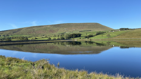
Photo
Where is located Black Moss Reservoirs
Black Moss Reservoirs — local attraction, which is located at 204,568 and 295,487 m3 (165.846 and 239.555 acre⋅ft) and belongs to the category — -. Average visitor rating for this place — 4.8 (according to 14 ratings, information from open sources and relevant for 2022).
Exact location — Black Moss Reservoirs, marked on the map with a red marker.
You can get directions to Black Moss Reservoirs on the map from your location.
What else is interesting in Nelson? You can see all the sights if you go to the city page.
Coordinates
Black Moss Reservoirs, United Kingdom coordinates in decimal format: latitude — 53.8664403321968, longitude — -2.268719902354298. When converted to degrees, minutes, seconds Black Moss Reservoirs has the following coordinates: 53°51′59.19 north latitude and -2°16′7.39 east longitude.
Nearby cities
The largest cities that are located nearby:
- Blackburn — 20 km
- Preston — 33 km
- Huddersfield — 35 km
- Manchester — 39 km
- Liverpool — 69 km
- Sheffield — 70 km
- Rotherham — 72 km
- Stoke-on-Trent — 92 km
- Telford — 129 km
- Sunderland — 130 km
- Sutton Coldfield — 142 km
- West Bromwich — 146 km
- Dudley — 147 km
- Birmingham — 151 km
- Leicester — 151 km
- Coventry — 165 km
- Worcester — 181 km
- Northampton — 198 km
- Cheltenham — 214 km
Distance to the capital
Distance to the capital (London) is about — 299 km.