 Herbertstown
Dromagh
Roughgrove
Millstreet
County Dublin
Athy
Sallins
Ballybunnion
Fethard
Herbertstown
Dromagh
Roughgrove
Millstreet
County Dublin
Athy
Sallins
Ballybunnion
Fethard
Ennis Friary on the map, Ennis, Ireland
Photo
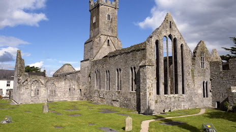
Where is located Ennis Friary
Ennis Friary — local attraction, which is located at Lower Abbey St, Lifford, Ennis, Co. Clare, Ireland and belongs to the category — monastery. Average visitor rating for this place — 4.4 (according to 339 ratings, information from open sources and relevant for 2022).
Exact location — Ennis Friary, marked on the map with a red marker.
You can get directions to Ennis Friary on the map from your location.
What else is interesting in Ennis? You can see all the sights if you go to the city page.
Coordinates
Ennis Friary, Ireland coordinates in decimal format: latitude — 52.84604912090316, longitude — -8.981425074630952. When converted to degrees, minutes, seconds Ennis Friary has the following coordinates: 52°50′45.78 north latitude and -8°58′53.13 east longitude.
Nearby cities
The largest cities that are located nearby:
- Cork — 111 km
- Belfast
 (United Kingdom) — 275 km
 - Liverpool (United Kingdom) — 400 km
- Preston (United Kingdom) — 423 km
- Blackburn (United Kingdom) — 437 km
- Telford (United Kingdom) — 439 km
- Glasgow (United Kingdom) — 445 km
- Exeter (United Kingdom) — 449 km
- Manchester (United Kingdom) — 449 km
- Stoke-on-Trent (United Kingdom) — 453 km
- Worcester (Great Britain) — 464 km
- Dudley (United Kingdom) — 466 km
- Bristol (Great Britain) — 467 km
- West Bromwich (United Kingdom) — 472 km
- Birmingham (United Kingdom) — 480 km
- Huddersfield (United Kingdom) — 480 km
- Sutton Coldfield (United Kingdom) — 482 km
- Cheltenham (United Kingdom) — 483 km
- Edinburgh (United Kingdom) — 497 km
Distance to the capital
Distance to the capital (Dublin) is about — 190 km.