
 Pfarrwerfen
Rosenau am Hengstpaß
Grinzens
Sankt Martin am Wöllmißberg
Sankt Martin am Silberberg
Söding
Felixdorf
Oberpullendorf District
Fließ
Pfarrwerfen
Rosenau am Hengstpaß
Grinzens
Sankt Martin am Wöllmißberg
Sankt Martin am Silberberg
Söding
Felixdorf
Oberpullendorf District
Fließ
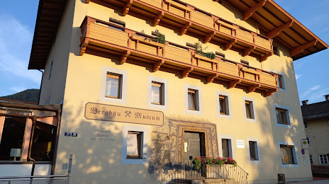
Bergbaumuseum Bad Häring on the map, Kufstein, Austria
Photo
Where is located Bergbaumuseum Bad Häring
Bergbaumuseum Bad Häring — local attraction, which is located at Dorfstraße 8, 6323 Bad Häring, Austria and belongs to the category — museum. Average visitor rating for this place — 4.4 (according to 16 ratings, information from open sources and relevant for 2022).
Exact location — Bergbaumuseum Bad Häring, marked on the map with a red marker.
You can get directions to Bergbaumuseum Bad Häring on the map from your location.
What else is interesting in Kufstein? You can see all the sights if you go to the city page.
Coordinates
Bergbaumuseum Bad Häring, Austria coordinates in decimal format: latitude — 47.51032946827235, longitude — 12.118540525176611. When converted to degrees, minutes, seconds Bergbaumuseum Bad Häring has the following coordinates: 47°30′37.19 north latitude and 12°7′6.75 east longitude.
Nearby cities
The largest cities that are located nearby:
- Innsbruck — 67 km
- Salzburg — 71 km
- Munich
 (Germany) — 75 km
 - Augsburg (Germany) — 127 km
- Ingolstadt (Germany) — 142 km
- Regensburg (Germany) — 158 km
- Linz — 175 km
- Ulm (Germany) — 184 km
- Trento
 (Italy) — 185 km
 - Nuremberg (Germany) — 221 km
- Fürth (Germany) — 226 km
- Vicenza (Italy) — 230 km
- Erlangen (Germany) — 237 km
- Venice (Italy) — 237 km
- Reutlingen (Germany) — 240 km
- Ljubljana
 (Slovenia) — 246 km
 - Trieste (Italy) — 247 km
- Graz — 253 km
- Pilsen
 (Czech Republic) — 254 km
Distance to the capital
Distance to the capital (Vienna) is about — 327 km.