
 Pfarrwerfen
Rosenau am Hengstpaß
Grinzens
Sankt Martin am Wöllmißberg
Sankt Martin am Silberberg
Söding
Felixdorf
Oberpullendorf District
Fließ
Pfarrwerfen
Rosenau am Hengstpaß
Grinzens
Sankt Martin am Wöllmißberg
Sankt Martin am Silberberg
Söding
Felixdorf
Oberpullendorf District
Fließ
Arnstein ruins on the map, Bad Vöslau, Austria
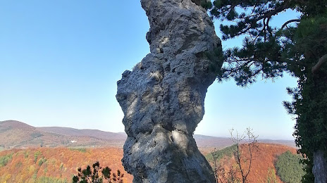
Photo
Where is located Arnstein ruins
Arnstein ruins — local attraction, which is located at 2534 Maria Raisenmarkt, Austria and belongs to the category — historical landmark. Average visitor rating for this place — 4.7 (according to 42 ratings, information from open sources and relevant for 2022).
Exact location — Arnstein ruins, marked on the map with a red marker.
You can get directions to Arnstein ruins on the map from your location.
What else is interesting in Bad Vöslau? You can see all the sights if you go to the city page.
Coordinates
Arnstein ruins, Austria coordinates in decimal format: latitude — 48.02967249234453, longitude — 16.066034025194668. When converted to degrees, minutes, seconds Arnstein ruins has the following coordinates: 48°1′46.82 north latitude and 16°3′57.72 east longitude.
Nearby cities
The largest cities that are located nearby:
- Bratislava
 (Slovakia) — 69 km
 - Győr
 (Hungary) — 111 km
 - Graz — 115 km
- Brno
 (Czech Republic) — 139 km
 - Linz — 147 km
- Székesfehérvár (Hungary) — 187 km
- Olomouc (Czech Republic) — 195 km
- Budapest (Hungary) — 217 km
- Salzburg — 235 km
- Zagreb
 (Croatia) — 238 km
 - Ljubljana
 (Slovenia) — 248 km
 - Ostrava (Czech Republic) — 252 km
- Pécs (Hungary) — 260 km
- Prague (Czech Republic) — 265 km
- Pilsen (Czech Republic) — 282 km
- Kecskemét (Hungary) — 288 km
- Rybnik
 (Poland) — 288 km
 - Bielsko-Biala (Poland) — 289 km
- Gliwice (Poland) — 311 km
Distance to the capital
Distance to the capital (Vienna) is about — 30 km.